Mount Harvard: A 14-mile day through the prettiest basin in the Sawatch
Third-highest in Colorado and the crown of the Collegiate Peaks. Horn Fork Basin makes the approach feel less like a 14er climb and more like a wilderness traverse — fourteen miles round-trip, and y'all are gonna remember every one.

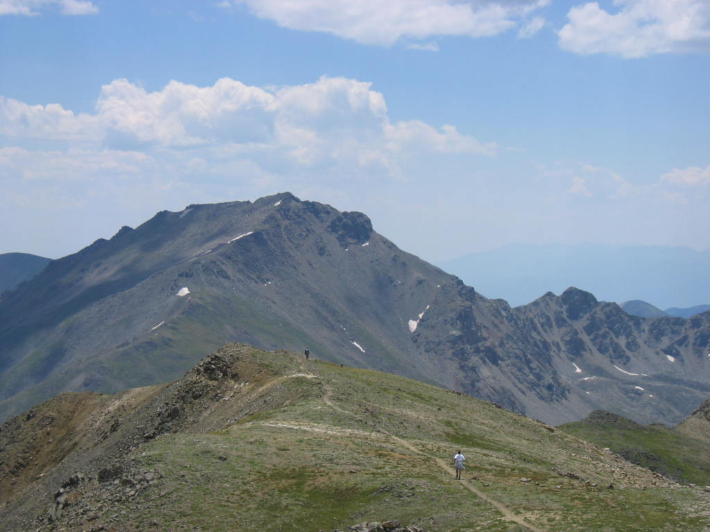
Mount Harvard sits at the back of Horn Fork Basin like the last peak in a postcard. The basin itself is the show — a deep glacier-carved cirque on the east side of the Sawatch with subalpine meadows, Bear Lake tucked at the upper end, and Harvard's broad south face capping it all. At 14,421 feet it's Colorado's third-highest peak and the high point of the Collegiate Peaks, that string of 14ers named after Ivy League schools by a Harvard climbing expedition in 1869.
Standard route is fourteen miles round-trip. That's a real number, especially with the upper face's loose talus tacked onto a five-and-a-half-mile basin approach. Strong day-hikers knock it out in 10 to 12 hours. Smart parties bivvy at Bear Lake the night before and split it across two days, which is honestly the move if you've got the gear — the basin's worth a sunset and a sunrise on its own merits.
The peak at a glance
- Elevation: 14,421 ft (4,396 m)
- Rank in Colorado: 3rd of 56 peaks above 14,000 ft
- Range: Sawatch Range — Collegiate Peaks
- County: Chaffee County
- Coordinates: 38.9244° N, 106.3206° W
- Standard route: South Slopes via Horn Fork Basin (Class 2) — 14 mi round-trip, ~4,600 ft gain
- Public land: Collegiate Peaks Wilderness, San Isabel National Forest
How Mount Harvard got its name
Summer 1869, a party led by Josiah Whitney (Harvard professor of geology, namesake of California's Mount Whitney) was working through the Sawatch on a mountaineering trip. They climbed the highest peak in what would become the Collegiate group, and per the survey-era playbook, they tagged it for their school. Mount Yale got the same treatment that summer. Mount Princeton and Mount Columbia followed in later survey rounds. Mount Oxford showed up in 1925 — a nod to the older university across the pond, and the only non-American name in the cluster.
The standard route
The play is the South Slopes via Horn Fork Basin. Start at the North Cottonwood Trailhead west of Buena Vista — there's a vault toilet, decent parking that fills before sunrise on summer weekends, and a clean trail. Hike 5.5 miles through lodgepole and spruce-fir up into the basin. Bear Lake shows up around mile 5, sitting at about 11,800 feet. From there the trail bends north, climbs the broad south face, and finishes on a steep talus scramble to the summit ridge. Footing on the upper pitch is mostly stable big blocks — pay attention, but it's not technical.
9 to 12 hours car-to-car is the right plan. The mileage and altitude don't compound — they multiply. Strong parties pair Harvard with Mount Columbia via the connecting ridge, a Class 3 traverse that adds three to four hours of loose-rock ridge walking. Worth doing once. Maybe.
Other ways up
The Harvard–Columbia traverse is the obvious add-on if your legs feel strong at the summit. The connecting ridge is loose, with a few honestly-exposed Class 3 steps, and Columbia's south-side descent has its own route-finding puzzle through old burns. Allow real time for it — this isn't a quick out-and-back.
The Frenchman Creek (East Slopes) approach is the historical alternate. Longer, brushy, bushwhacking through burn scars. Rarely climbed anymore. There's a reason.
When to climb
The Colorado fourteener climbing season is short. The standard window runs from late June through mid-September — after the snow has melted off the trail and before the first serious autumn storm. Outside that window, you're committing to a winter ascent: snow travel, avalanche assessment, post-holing through drifts, and route-finding without a visible trail.
Inside the window, the rule that has saved more Colorado lives than any other is be off the summit by noon. Afternoon convective storms build over the high peaks almost daily in July and August. Lightning is the leading weather killer in the Rockies. Plan for a pre-dawn start — most experienced climbers leave the trailhead between 4:00 and 5:30 AM.
Where it sits
The Collegiate Peaks are the central segment of the Sawatch, running south from Mount Massive down to Mount Antero. The whole range sits inside the Collegiate Peaks Wilderness — third-largest designated wilderness in Colorado, and one of the cleanest. Trailheads cluster on the east side from Buena Vista north to Granite. Buena Vista (locals say "BEW-na," not "Bweh-na") is the staging town. The Eddyline Brewery and the Buena Viking diner are the unofficial post-climb spots.
What climbers wish they'd known
The basin tricks people. The first five miles are gorgeous and rolling and basically flat. Easy to set a pace that feels sustainable. Then you hit mile 6 with the upper face stretched out above you and 2,000 vertical feet still to gain at altitude, and suddenly the math is different. Pace yourself in the basin like you're already tired.
Bear Lake is the bivvy. Flat ground above the lake around 12,400 ft, established sites, no permit needed (Forest Service backcountry rules apply). 200 feet from water, pack everything out. Splitting Harvard across two days is the right call if you have the time — you get a sunset and a sunrise out of it, and the climb feels half as hard the next morning.
The summit cairn is sneaky. The actual high point is a small block, easy to walk past on the broad summit ridge. Look for the USGS benchmark on the rock and the small cairn — that's the spot.
Before you go
A 14er is a long, exposed day at altitude. Read these first if you haven't already:
- Planning your first multi-day backpacking trip — same logistics apply to a long single-day summit push.
- How to choose the right trail difficulty — converting class ratings into honest fitness estimates.
- Leave No Trace, in one minute — alpine tundra heals on a geological clock. Stay on the trail.
Looking for the standard route on the map? Browse Colorado trails on the Outdoors App or jump to the Near Me view if you're already in-state.
If you liked this peak
- Mount Columbia — the Harvard–Columbia traverse
- Mount Yale — same expedition, different campus
- Mount Princeton — the Collegiate showpiece
Hero photograph: Mount Harvard rising at the head of Horn Fork Basin in the Collegiate Peaks Wilderness, Colorado. by jokermanj, licensed under CC BY 2.0.


