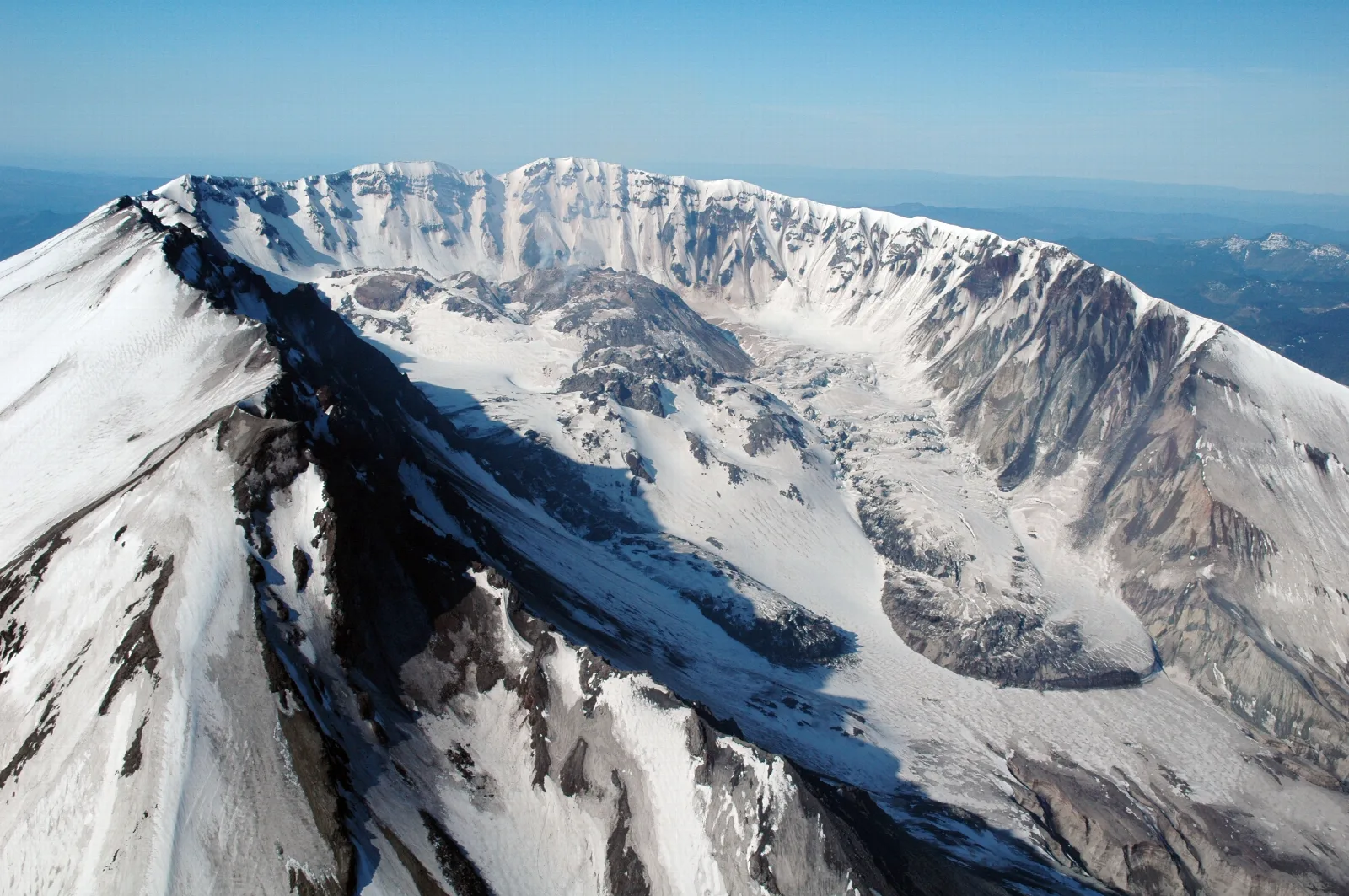
The Glacier That Grew Inside Mount St. Helens
Almost every glacier story in the Cascades is a story about loss. Inside the crater at Mount St. Helens, ice did something else. It showed up after 1980, in a hole the eruption made, and by the time USGS mapped it in September 2001 it covered more ground than all the mountain's other remaining glaciers combined.

Almost every glacier story in the Cascades is a story about subtraction. Across the range in North Cascades National Park, the National Park Service counts over 300 glaciers and countless snowfields, the most heavily glaciated area in the United States outside Alaska, and says plainly that most have shrunk dramatically during the last century. That is the baseline. That is what glacier reporting in this part of the world sounds like.
Mount St. Helens is the exception, and it got there the hard way. On May 18, 1980, as USGS puts it, the upper 400 m (1,300 ft) of the summit was removed by a huge debris avalanche, leaving a 2 x 3.5 km horseshoe-shaped crater now partially filled by a lava dome and a glacier. The crater opens into what the USGS scientists who later mapped the ice called a large, north-facing amphitheater. Then ice began accumulating in it: new ice, in a hole that had not existed before.
- Crater: 2 x 3.5 km, horseshoe-shaped, opening into a north-facing amphitheater
- Removed on May 18, 1980: the upper 400 m (1,300 ft) of the summit
- Glacier area, September 1996: about 0.1 km²
- Glacier area, September 2001: about 1 km² — roughly ten times as much, five years later
- Maximum thickness (2001): about 200 m
- Estimated volume: 120,000,000 m³ of ice and rock debris, roughly one third of it rock
- Lava dome emplaced through the ice: September 2004
- Standard route: Monitor Ridge — non-technical, 4,500 ft in five miles, ends at the rim
A shadow is all it took
The 1980 collapse left a steep headwall rising 700 m above the crater floor. That wall throws shade. Snow and avalanche debris pile into the amphitheater below it and the sun never gets a full day at them. Rock and ash off the walls fall on top and insulate what is already there.
So the crater does something the rest of the mountain cannot. It holds snow through the melt season, year over year, until the pile is deep enough to behave like a glacier. Schilling and his USGS coauthors described the result exactly that way: a glacier formed in a deeply shaded niche.
This is not evidence that Cascade glaciers generally are doing fine — it is a local geometry problem producing a local result.
What the numbers say
The measurements come from a 2004 study in Quaternary Research by S. P. Schilling, P. E. Carrara, R. A. Thompson, and E. Y. Iwatsubo of the USGS, which mapped the crater ice as it developed.
- In September 1996, the glacier covered roughly 0.1 square kilometers.
- By September 2001, it covered about 1 square kilometer. Roughly ten times the area in five years.
- Maximum thickness in 2001 was about 200 meters.
- Total volume was an estimated 120,000,000 cubic meters of ice and rock debris.
- About one third of that volume is thought to be rock debris, not ice.
A third of the volume is rock, derived mainly from rock avalanches off the surrounding amphitheater walls. This is a dirty, rubble-loaded glacier, and the debris layer is insulation — part of why it survives in a place that should be too warm and too low for it.
The sharpest comparison in that study is an area comparison, and it is worth stating precisely. As of the September 2001 mapping, the crater glacier was the largest glacier on Mount St. Helens, and its aerial extent exceeds that of all other remaining glaciers combined. The ice that arrived after the mountain blew up covered more ground than all the ice left over from before it.
The mountain's own height has been restated in the same period. A survey in 1982 gave a measurement of 2,549.7 m (8,365 ft). A lidar survey done in 2009 found the maximum elevation to be 2,539 m (8,330 ft). Both numbers are still in circulation on official pages.
Then a lava dome came up through it
Mount St. Helens reawakened in September 2004. A silicic lava dome pushed up through the crater floor, directly into the glacier that had been accumulating there since 1980. Joseph S. Walder, Steve P. Schilling, James W. Vallance, and Richard G. LaHusen documented what followed in USGS Professional Paper 1750-13, published in 2008. Their finding: during the 2004-6 eruption, the process of lava-dome emplacement through a glacier was observed for the first time.
Observed for the first time, which is not a claim that it had never happened before. It is a claim that nobody had ever been in position to watch it.
The glacier was split in two by the new dome, and the two halves were then successively squeezed against the crater wall. Photography, photogrammetry, and geodetic measurement recorded deformation the team described as of an extreme variety, with strain rates of extraordinary magnitude compared to normal temperate alpine glaciers.
The ice also behaved strangely in a way that took some work to explain. Unlike ordinary alpine glaciers, the crater glacier showed no speed-up at the start of the ablation season and no diurnal speed fluctuations during it. The team concluded there is evidently no slip of the glacier over its bed. Their proposed explanation is that meltwater working down through the ice gets captured by a thick layer of coarse rubble at the bottom and drains into the volcano's groundwater system, instead of feeding the bed drainage network that normally lets a glacier slide.
A glacier that does not slide, because the volcano underneath it drinks the meltwater. Walder, Schilling, Sherrod, and Vallance continued the photographic record through November 2009 in USGS Open-File Report 2010-1141.
What we are not going to tell you
You will find this glacier described in a lot of places as the youngest glacier in North America and the fastest growing glacier on the continent, sometimes with specific advance rates attached. We went looking for a primary source for those claims and could not land one, and the current USGS material we could reach does not repeat them.
So we are leaving them out. What is documented is documented: the ice formed after 1980, it was measured growing sharply between 1996 and 2001, its aerial extent in 2001 exceeded that of the mountain's older glaciers combined, and a lava dome came up through the middle of it starting in September 2004. That is a good enough story without the superlatives, and the superlatives are the part that would get corrected.
What you can actually see from Monitor Ridge
Be clear about this, because it is a common misunderstanding about climbing Mount St. Helens: the standard route does not go anywhere near the glacier.
The Forest Service's summit climbing page describes Monitor Ridge this way: this route gains 4,500 feet in five miles to the crater rim at 8,365 feet elevation. Most climbers complete the round trip in seven to twelve hours. It is a non-technical climb, and the agency's caveat is about fitness and footing rather than skill — be in good physical condition and be ready to scramble on steep, rugged ground.
What Monitor Ridge gets you is the rim. You stand on the edge and look down at the crater, the lava dome, and the ice. You do not walk on it. Entry into the crater is strictly prohibited.
The rim itself is the hazard, and the Forest Service is specific about why. A cornice — an overhanging mass of snow formed by wind — builds through the winter on the leeward side of the crater rim, which means the visible edge is not the real edge, and it is fragile and extremely dangerous to walk upon. Their instruction is to stay back at least 30 ft (9 m) from the visible edge. There is elevated avalanche danger and rockfall during the spring thaw.
Climbing permits are required and limited to daily quotas from April 1 to October 31 for anyone traveling above 4,800 ft. In that window, permits are sold online, in advance, on a first-come, first-served basis on Recreation.gov, with a daily limit of 350 climbers from April 1 to May 14 and 110 climbers from May 15 to October 31. From November 1 to March 31 permits are free of charge and self-issued at the trailhead, with no limit on the number of climbers. Those figures are what the agency page carries as of publication — check it before you plan anything, because quotas and closures move.
Why this one is in the series
The rest of this series is about glaciated volcanoes where the ice is the route and the ice is the danger. Here the ice is the subject and it is off limits. The climb ends at the rim, and the crater below it is closed.
It is in the series as the control case. This mountain grew a glacier inside a crater in twenty years, USGS measured it going from about 0.1 to about 1 square kilometer between 1996 and 2001, and then a lava dome came up through the middle of it while scientists watched.
You can see all of it from the rim, without ever setting foot on a glacier.
Sources
- USGS — Mount St. Helens volcano overview (crater dimensions, 1980 summit loss, 1982 and 2009 elevation surveys)
- Schilling, Carrara, Thompson & Iwatsubo (2004) — Post-eruption glacier development within the crater of Mount St. Helens, Washington, USA, Quaternary Research
- Walder, Schilling, Vallance & LaHusen (2008) — Effects of lava-dome growth on the Crater Glacier, USGS Professional Paper 1750-13
- Walder, LaHusen, Vallance & Schilling (2007) — Emplacement of a silicic lava dome through a crater glacier: Mount St Helens, 2004-06, Annals of Glaciology
- Walder, Schilling, Sherrod & Vallance — Photographic documentation of the evolution of Crater Glacier, USGS Open-File Report 2010-1141
- National Park Service — Glaciers of North Cascades National Park
- USDA Forest Service, Gifford Pinchot National Forest — Mount St. Helens summit climbing (Monitor Ridge, permits, crater closure)
- Wikimedia Commons — hero photograph file page (Jon Major, USGS, public domain)
Keep reading
- The Wonderland Trail: a lap around the most glaciated peak in the lower 48
- The Pacific Northwest Trail, Continental Divide to the Pacific
Hero photograph: Aerial view into the crater of Mount St. Helens from the northeast, May 8, 2007, with the growing lava dome on the crater floor and Crater Glacier wrapped around it. by Jon Major, U.S. Geological Survey, USGS Cascades Volcano Observatory. Public domain.


