Status unknown — verify before visiting
We don't have current condition data for this trail. Check with the land manager before you go.
11.5 mi
Distance
1,375 ft
Elev. Gain
4h 24m
Est. Time
Loop
Route Type
Difficult
Difficulty
About This Trail
Imported descriptionTrail Conditions
Trail Conditions
We have no current condition data for this trail. Check with the operator before you go, and submit a report below if you've been recently.
No recent condition reports. Be the first to share what you see on the trail.
Elevation Profile
Trail Details
- Route Type
- Loop
- Surface
- Dirt
Official sources & verification
We don't have curated agency sources for this trail in our cache yet. Outdoors is not the permitting authority — confirm conditions, permits, and access with the managing agency before you go. If you know who manages this trail, please tell us.
Reviews
No reviews yet
Be the first to share your experience and help others plan their visit.
Legacy import — verify before navigating
Path geometry came from our pre-launch legacy database. Routes have not yet been re-verified against the operator and may differ from the actual trail.
Nearby Trails
More trails near Holly Ridge Conservation Area
Stay nearby
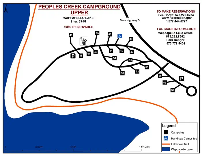
Campgrounds near this trail
Similar length
Similar trails in Missouri
Lewis and Clark Trail and Lewis Trail Loop
Missouri
Chubb Trail via West Tyson Trailhead
Missouri
Lost Valley Trail Loop
Missouri
Zombie Trail
Missouri
Forest Park Heels Path
Missouri
Smithville Lake Trails
Missouri