Parks in Utah
Explore 365 parks and public lands with richer details on amenities, trail access, and park types.
Crocodile Staging Area
Utah
Crocodile Staging Area provides a convenient parking and staging location for ATV/UTV riders interested in exp…
Cross Canyon
Utah
This WSA includes portions of three main canyons which are the continuation ofthe Cahone Canyon WSA. The relat…
Dandelion Flat Picnic Area
Utah
At an elevation of over 8,000 feet, and surrounded by pine and aspen trees, Dandelion Flat includes fire rings…
Dark Canyon SRMA
Utah
Dark Canyon begins high on the edge of Elk Ridge (8,800 feet in elevation) and ends at 3,700 feet elevation in…
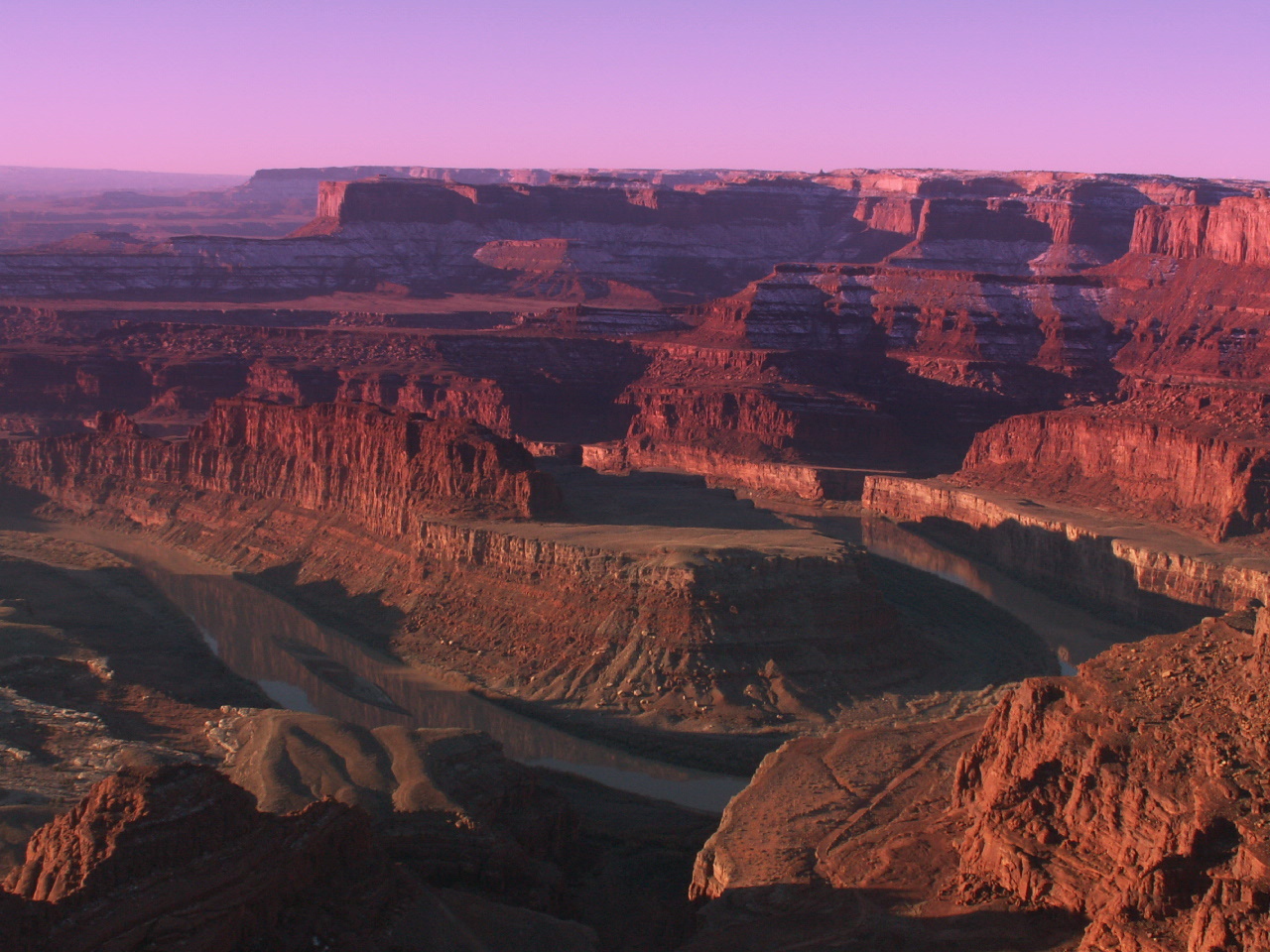
Dead Horse Point State Park
Utah
Visitors to Dead Horse Point State Park are in for a treat. Driving to each of the park’s many overlooks revea…
Dead Horse Point State Park
Utah
Dead Horse Point offers stunning overlooks of the Colorado River and Canyonlands. The mesa-top park provides s…
Death Ridge
Utah
The southern part of the WSA consists of benches and canyons and the northern portion is composed of ridges di…
Deep Creek North Wilderness
Utah
Deep Creek Wilderness and Deep Creek North Wilderness These two contiguous units, containing approximately 7,5…
Deep Creek Wild and Scenic River
Utah
Deep Creeks origin is to the north of the BLM parcel and on private lands. This spectacular section of the str…
Deep Creek Wilderness
Utah
Deep Creek Wilderness and Deep Creek North Wilderness These two contiguous units, containing approximately 7,5…

Deer Creek Reservoir
Utah
Recreation at Deer Creek Dam and Reservoir, Provo River Project, is managed by the Utah Division of Parks and …
Deer Creek State Park
Utah
Utah State Parks: Windsurf, boat, zip line and fish on the cool waters of Deer Creek Reservoir. The nearly 3,0…
Devil's Garden
Utah
The Devil’s Garden is located in Garfield County, Utah, USA, and is part of the Grand Staircase-Escalante Nati…
Devils Canyon
Utah
It is a rugged, sinuous gorge with numerous short tributary canyons that drain westward toward Muddy Creek. Po…
Dinosaur National Monument
Utah
150 million years ago, dinosaurs roamed here. Their fossils are still embedded in the rocks. Today, mountains,…
Dirty Devil River
Utah
Named by John Wesley Powell during a mapping expedition in the late 1800s, this river and its many tributaries…
Dixie National Forest
Utah
Utah's largest national forest at nearly two million acres, Dixie stretches 170 miles across southern Utah's s…
Dixie National Forest
Utah
Dolores River (CO)
Utah
The lower stretch of the Dolores River offers technical rapids, stunning scenery, wildlife viewing, side-canyo…
Dolores River (UT)
Utah
The Utah section of the Dolores River offers technical rapids, stunning scenery, wildlife viewing, side-canyon…
Dolores River SRMA
Utah
This 102 mile stretch of river carves its way through broad valleys and incised canyons with sheer canyon wall…
Dominquez Escalante Trail
Utah
On July 29, 1776, Father Francisco Atanasio Dominguez and Father Silvestre Velez Escalante set out from Santa …
Dominquez-Escalante Trail
Utah
Dominquez-Escalante Trail, 1776-1777, is a segment of the likely route followed by the Dominquez-Escalante exp…
Drinks Canyon Camping Area
Utah
Drinks Canyon Camping Area is located 6.2 miles from the junction of Highway 191 on Highway 128. There are thr…