How the Appalachian Trail Invented the Thru-Hike
Earl Shaffer walked out of Georgia in 1948 with no tent and no stove, and the Appalachian Trail Conference didn't believe him. Seventy-eight years later, the ATC's own numbers say one in four northbounders who attempt the 2,197.9-mile walk actually finish it.

Earl Shaffer walked out of Georgia on April 4, 1948, carrying a worn Army rucksack, no tent, and no stove. He had spent the war as a forward-area radioman in the South Pacific, and Walter Winemiller — the friend he'd planned to hike with — had been killed in the landings at Iwo Jima. Shaffer said he needed to walk the war out of his system, so he pointed himself at Maine and averaged seventeen miles a day for 124 days straight.
Nobody had ever walked it all in one season. When Shaffer reported that he had, the Appalachian Trail Conference assumed the claim was fraudulent and made him defend it, diary and photographs in hand. He passed. The organization — today's Appalachian Trail Conservancy — recognized him as the first, put his name on a roster that has since grown past 20,000, and a thing called thru-hiking existed. Other hikers took to calling him The Crazy One. He didn't seem to mind.
- Official length (2026): 2,197.9 miles — the ATC remeasures every year as reroutes land
- States: 14, Georgia to Maine
- Termini: Springer Mountain, GA → Katahdin, ME
- Typical thru-hike: 5–7 months; the ATC's average is just under six
- First reported thru-hike: Earl Shaffer, 1948, in 124 days
- Proposed / completed: October 1921 essay; final section cut August 14, 1937
- 2025 northbound finish rate: 25% — 550 of 2,187 registered starters
Fourteen states in one unbroken line
The map below is the whole argument. Set the dot loose at Springer Mountain and it rides high ground through fourteen states — Georgia's oak ridges, the Smokies crest, roughly a quarter of the entire distance in Virginia alone, then the mid-Atlantic ledges and New England's granite until the land runs out at Katahdin. It is one continuous, white-blazed footpath, maintained end to end by volunteer clubs. That's the definition of a trail this series will work from — at least until the Continental Divide shows up to argue with it.
Every state crossing, shelter-heavy stretch, and elevation mile of the line is browsable on the Appalachian Trail page on Outdoors.
The essay that came before the footpath
The trail arrived on paper in October 1921, when a forester and regional planner named Benton MacKaye published "An Appalachian Trail: A Project in Regional Planning" in the Journal of the American Institute of Architects. It barely reads as a hiking proposal. MacKaye wanted a chain of camps and cooperative communities along the Appalachian crest where industrial workers could recover from city life; the footpath was connective tissue. Walking the whole thing end to end appears nowhere in his plan.
Volunteers built it anyway, section by section, through hundreds of local clubs over sixteen years. A six-man Civilian Conservation Corps crew cut the final two miles on the ridge between Spaulding and Sugarloaf mountains in Maine on August 14, 1937 — the plaque marking the spot wasn't dedicated until fifty years later, to the day. Eleven years after the trail closed its last gap, Shaffer supplied the use case MacKaye never wrote down, and the argument between those two ideas of the trail — a place to stop versus a thing to finish — has been running ever since.
How long does it take to thru-hike the Appalachian Trail?
Five to seven months for most hikers; the Appalachian Trail Conservancy puts the average at just under six. Shaffer's 124 days would still read as fast today.
That duration sets the calendar. Most northbounders leave Georgia between mid-February and mid-April and need to be on top of Katahdin before Baxter State Park closes the trail to its summit in mid-October — the ATC's guidance is to arrive by October 15 — which means the season chooses your start window for you. If you're reading this in July, you're not late — you're early. A serious attempt gets planned the autumn and winter before, and the ATC runs a voluntary registration system, ATCamp, that lets you pick a start date away from the worst of the Amicalola Falls crowds.
One in four: the finish rate nobody frames
In 2025, 2,187 northbound thru-hikers registered their starts at Amicalola Falls. Five hundred fifty reported finishing — 25 percent, straight from the ATC's 2,000-miler records. Southbounders did marginally better, at 31 percent.
Finish, and you join the roster the ATC has kept since Shaffer: report the hike and you're a 2,000-miler, certificate and rocker patch included. The trail is 2,197.9 miles this year — the ATC remeasures annually — and the name has never bothered to keep up.
As for what separates the 25 percent from everyone else: it isn't gear, and hasn't been since 1955. That year Emma "Grandma" Gatewood — 67 years old, mother of eleven, grandmother of twenty-three — walked the whole trail in Keds sneakers, carrying her supplies in a small knapsack. Then she came back and completed it twice more. Gatewood is the standing rebuttal to every gear-list panic a first-timer has ever had. The trail does not care what your pack cost.
Do you need permits for an A.T. thru-hike?
There is no single permit for the whole trail. Three stretches require paperwork: Great Smoky Mountains National Park issues a dedicated thru-hiker permit (now handled through Recreation.gov), Shenandoah National Park requires a backcountry permit, and Baxter State Park requires every long-distance hiker to pick up its Long Distance Hiker permit in person at Katahdin Stream before climbing Katahdin. Current procedures for all three live on the ATC's permits page — check it the winter before you go, because the mechanics shift more often than the trail does.
Where this series goes next
This is the first in a daily series of American long-trail profiles — the Pacific Crest, the Continental Divide, and the rest of the country's long walks follow, one each morning in the Outdoors Journal. If a six-month walk is more commitment than you're ready to name, start smaller — planning your first multi-day trip uses the same resupply logic at weekend scale, and Leave No Trace, in one minute matters double on a footpath that exists only because volunteers keep rebuilding it. When you're ready to pick a long walk of your own, the trail maps on Outdoors are free to wander.
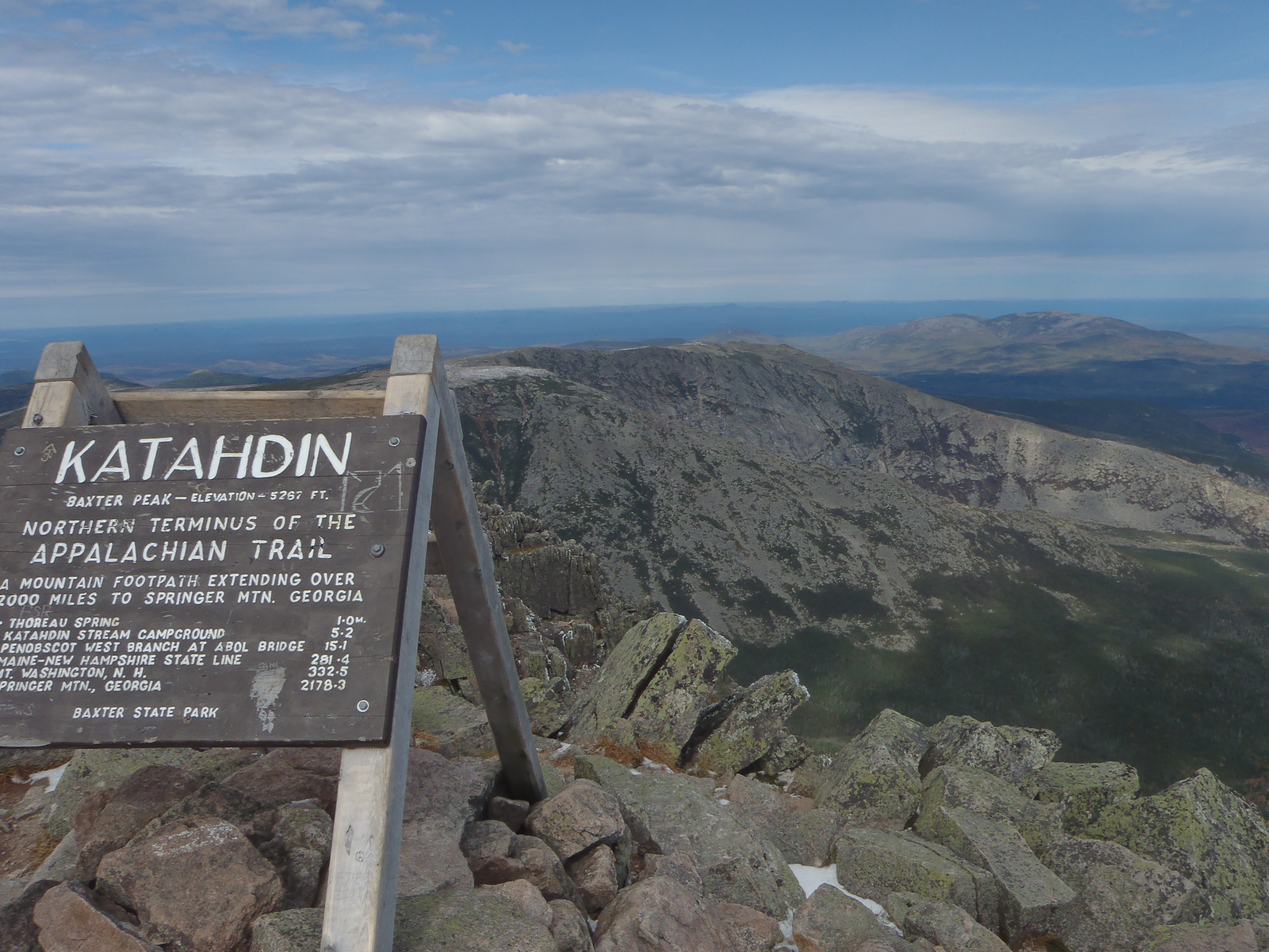
Hero photograph: The sign marking the Northern Terminus of the Appalachian Trail on Baxter Peak of Katahdin. by Dylan, licensed under CC BY-SA 3.0.
Sources
- appalachiantrail.org
- appalachiantrail.org
- appalachiantrail.org
- en.wikipedia.org
- appalachiantrail.org
- appalachiantrail.org
- en.wikipedia.org
- livingnewdeal.org
- appalachiantrail.org
- en.wikipedia.org
- commons.wikimedia.org
Hero photograph: The sign marking the northern terminus of the Appalachian Trail on Baxter Peak of Katahdin. by Dylan, licensed under CC BY-SA 3.0.


