Thru-hike planner
Superior Hiking Trail
Thru-hike planner
Superior Hiking Trail
300-mile thru-hike planner: permits, resupply and the places along the route
Shared by Outdoors Support
- Markers
- 83
- Resources
- 1
- Distance
- 300.0 mi
- Elevation
- —
- Markers
- 83
- Resources
- 1
- Distance
- 300.0 mi
- Elevation
- —
Notes
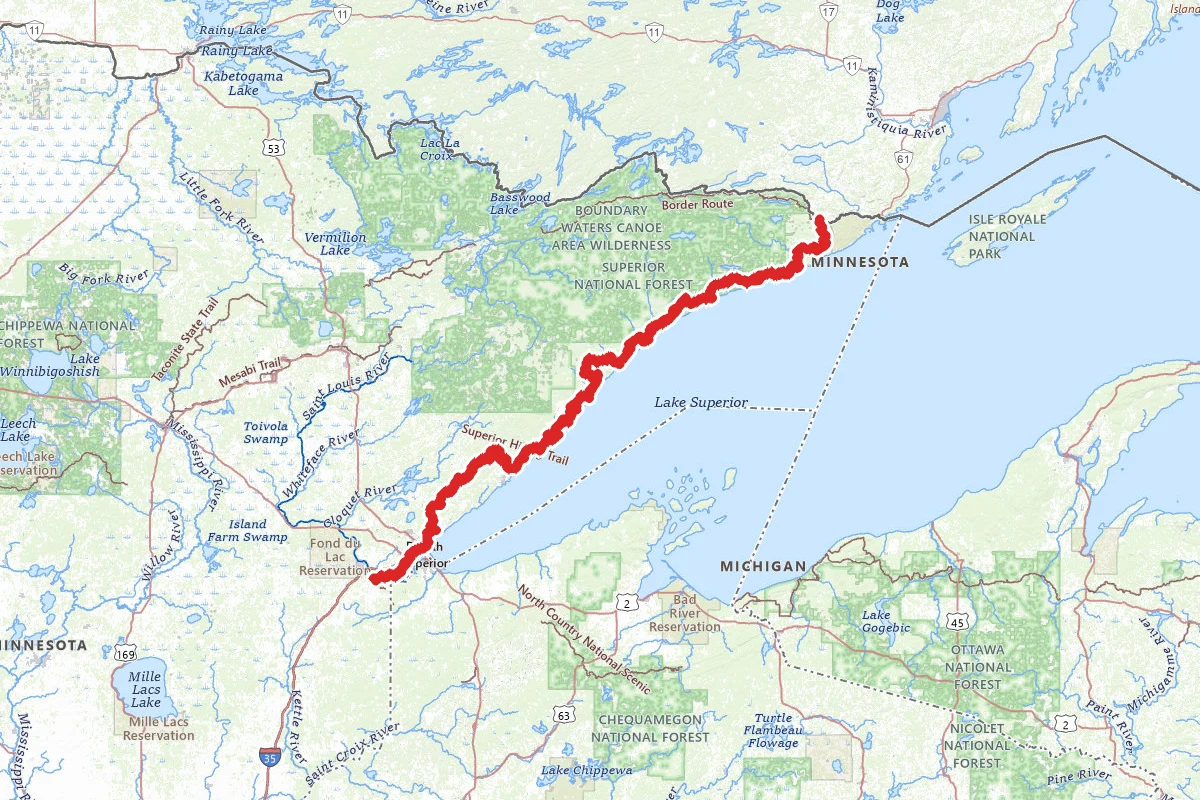
The Superior Hiking Trail runs through northeastern Minnesota along the North Shore of Lake Superior. It starts south of Duluth and ends at the 270-degree Overlook near the Canadian border. The Superior Hiking Trail Association (SHTA) counts 300 miles of main trail, plus 41 miles of spur trails. A full end-to-end hike generally takes 2 to 4 weeks, and the SHTA recommends a one- or two-night shakedown trip first to learn your pace and test your gear. You can walk it either way. The SHTA suggests beginners start at the southern end, where the terrain is gentler and bail-out points are easier to reach between Duluth and Two Harbors. Summer is the SHTA's pick for longer trips. Fall works too: bugs are gone after the first frost. In spring, snow lingers into mid or late May, the north can run two weeks behind the south, and the melt leaves mud, so the SHTA suggests planning big trips for another time.
You do not need a permit to hike the trail or to stay at its 94 backcountry campsites. There are no fees and no reservations, and the sites are shared, so you can't reserve one. Most hold 2 to 5 tents around a fire ring and a backcountry latrine. Stay one night at each. If every tent pad is taken, camp near the established pads and share the fire ring and latrine rather than making a new site. The trail also passes several state park campsites. Those need a reservation and a fee through the state parks, so don't use one unless you have booked it. Any vehicle entering a Minnesota state park needs a state park vehicle permit. Groups of 8 or more camping 3 nights or more should send the SHTA a Trail Use Notification. It is not a reservation. Camping anywhere except the designated sites is prohibited, and so is camping at trailheads.
The trail runs between 602 and 1,829 feet above sea level. You climb to rock outcrops and cliffs, then drop to rivers and streams. Many stream crossings have no bridge. They are usually shallow, but heavy rain or the spring melt can make them impassable. The SHTA tells hikers to prepare for ticks, mosquitoes and black flies between April and October, and ticks can be active whenever it is above freezing. Lake Superior weather can change fast: it can be in the 40s in July and 90 degrees in September, and the SHTA advises three-season gear from May to October and four-season gear from October to May. The trail crosses more than 80 private parcels that are usually not marked, so stay on the blazes. Spur and overlook trails are blazed white, and a turn is marked with two blazes, the upper one showing the direction. The SHTA warns that unofficial guides and GPS apps have carried wrong trail information, and recommends its own guidebook, databook and maps. Cell service is limited, most of all in the north. Call 911 in an emergency.
Most campsites sit near a natural water source, but not all. The SHTA guidebook gives the water source for each campsite. Treat all water from rivers and lakes. Smaller sources can dry up in late summer. SHTA trailheads have no water, toilets or trash bins, though trailheads shared with city parks or waysides may. At camp, secure your food with a bear canister or hang it in a bear bag. Dogs are welcome but must be on a leash at all times; pack animals are not allowed.
You can't carry weeks of food, so plan a few resupply stops. Supplies can be picked up in several small towns not directly on the trail, so you need to walk or get a ride. Some businesses will hold a package, but you must arrange it with them before you mail anything. The SHTA package-hold list names places in Beaver Bay, Finland, Tofte and Grand Marais, plus the SHTA office in Two Harbors. Superior Shuttle will also deliver packages to trailheads if you arrange it with them.
There are no regular transit services near either end of the trail. The SHTA does not run shuttles, but several private shuttle services serve the trailheads. Some, including Superior Shuttle, serve the whole trail, both ends included. In late summer and early fall shuttles can be fully booked, so line up a ride before you leave. A flip-flop hike lets you leave your car in the middle and shuttle to either end. Most trailheads in Duluth, and those at Highway 61 waysides, do not allow overnight parking. The southern segment through Duluth has one SHTA campsite, at the Red River. There are no SHT campsites inside the city limits, so plan on fee campgrounds near the trail, such as Spirit Mountain, Bagley Nature Area or Indian Point, or other lodging. Campfires are prohibited within Duluth city limits.
Check the SHTA Trail Conditions page before you go and whenever you have service on the trail. The Duluth section closes during the spring thaw, about April 1 to mid-May, and again in the fall freeze and thaw. Much of the trail north of Duluth closes for the November firearms deer season, and Minnesota state parks may limit access during their managed hunts. Closures are signed at nearby trailheads, and the SHTA posts a reroute when a section closes. Report damage with the Trail Incident Report form. Wear blaze orange in hunting season. Hikers who finish every mile can apply to the SHTA's End-2-Ender program.
Permits and official resources
Straight from the agencies and the trail's managing association. Rules and permit systems change, so check these pages before you go.
Permits
- Camping reservations and permits (SHTA) Superior Hiking Trail Association
- Large groups and events (Trail Use Notification) Superior Hiking Trail Association
- Minnesota state park vehicle permits Minnesota DNR
Plan your hike
- Thru-hiking the Superior Hiking Trail Superior Hiking Trail Association
- Trail conditions and closures Superior Hiking Trail Association
- Know before you go Superior Hiking Trail Association
- Parking and shuttles Superior Hiking Trail Association
- Guidebooks and maps Superior Hiking Trail Association
- Trail sections Superior Hiking Trail Association
- Backpacking and seasons Superior Hiking Trail Association
- FAQs Superior Hiking Trail Association
- Trail incident report Superior Hiking Trail Association
- Superior National Forest alerts USDA Forest Service
- Minnesota state park rules Minnesota DNR
- End-2-Ender program (recognition for hiking the whole trail) Superior Hiking Trail Association
- SHTA Trail Store: guidebook, databook, atlas and section maps Superior Hiking Trail Association
- Leave No Trace on the SHT Superior Hiking Trail Association
- Plan your adventure (seasons, guidebook, databook, atlas) Superior Hiking Trail Association
Who to call
- Superior Hiking Trail Association218-834-2700info@superiorhiking.orgPO Box 315, 618 1st Avenue Two Harbors, MN 55616
- Minnesota DNR Information Center (state parks)Minnesota Department of Natural Resources651-296-6157
- Superior National Forest Supervisor's OfficeUSDA Forest Service — Superior National Forest(218) 626-43008901 Grand Avenue Place Duluth, MN 55808
Books for the trail
- Superior Hiking Trail Guidebook (opens in new tab)Guidebook · Superior Hiking Trail Association · Superior Hiking Trail Association · 10th edition (2025)The official guide: mile-by-mile sections, every campsite and the distances between them, water sources and overnight parking.
- Superior Hiking Trail Databook (opens in new tab)Data book · Superior Hiking Trail Association · Superior Hiking Trail Association · First edition (2020)A 3-ounce condensed guide: mile points between trailheads, campsites, water crossings and junctions, with elevation profiles for the main trail.
- Trail Atlas of the Superior Hiking Trail (opens in new tab)Maps · Superior Hiking Trail Association · Superior Hiking Trail Association · 2nd edition (2025)Full-trail topo maps with campsites, trailheads, water features and roads into town; carry only the pages you need.
Links go to the publisher or the trail association. Check for the current edition.
Markers (83)
Trails (1)
Reviews
No reviews yet
Be the first to share your experience and help others plan their visit.