Thru-hike planner
Pinhoti Trail
Thru-hike planner
Pinhoti Trail
335-mile thru-hike planner: permits, resupply and the places along the route
Shared by Outdoors Support
- Markers
- 52
- Resources
- 1
- Distance
- 335.0 mi
- Elevation
- —
- Markers
- 52
- Resources
- 1
- Distance
- 335.0 mi
- Elevation
- —
Notes
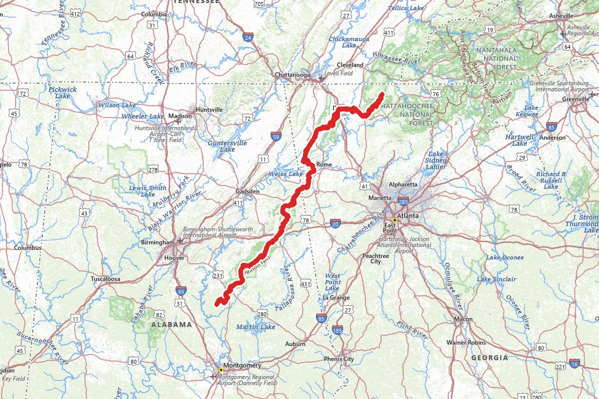
The Pinhoti Trail starts on Flagg Mountain in Alabama, and runs north through the Talladega National Forest and into Georgia. It ends where it meets the Benton MacKaye Trail on the South Fork of Jacks River, in the Conasauga Ranger District. Published lengths differ. The Alabama Trails Commission gives the Alabama half as 171 miles. The Forest Service says Georgia has over 160 miles. The Alabama Trails Foundation calls the whole trail over 335 miles, and the Georgia trail association's guide counts 169.2 miles from the state line.
The Pinhoti Outdoor Center says the trail is at its best in fall, winter and spring, when the weather is manageable, water is flowing and volunteers keep the trail up. It strongly discourages long-distance hiking in Alabama in peak summer. Heat illness is the first reason it gives. Many natural water sources dry up or slow to a trickle, and the trail overgrows, which hides snakes, wasps and ticks.
The route crosses six land ownerships in Alabama alone, so permit and camping rules depend on who manages the ground. Check each manager before you go. The Forest Service says no permit is needed to hike and backpack in the Cohutta Wilderness. Flagg Mountain sits in Weogufka State Forest, run by the Alabama Forestry Commission. Its two cabin shelters and its campsites are rented through the Alabama Trails Foundation's Flagg Mountain page, and they are closed Monday through Wednesday, so plan your start around that. The Forestry Commission says overnight camping there must be reserved in advance, and bathroom facilities are limited. Camping inside Cheaha State Park is by reservation, and you check in at the Mountain Store. National Forests in Alabama limit dispersed camping to 21 consecutive days. Motors are not allowed on the trail except where it follows public roads. In Georgia the trail is also open to horses and mountain bikes on most sections, so expect to share it. Bikes are kept off Bear Creek Loop to the Mountaintown Creek Trail, horses off the Hurricane Trail junction to Dug Gap and Tatum Lead Road to Buddy Cove Gap, and both take the northern route around Keown Falls and Pilcher Pond.
From Flagg Mountain the Alabama trail crosses six U.S. highways and climbs over Rebecca, Horn, Cheaha, Dugger and Indian mountains. The high ground is Cheaha State Park, which the park describes as Alabama's highest point, set at 2,407 feet. In Georgia the trail goes through Cave Spring, follows Taylor's Ridge toward Dalton, then heads for the Cohutta area. The Georgia guide lists sections of 15.8 miles (Snake Creek Gap to Dug Gap) and 18.2 miles (Ramhurst to Cohutta Overlook). The Georgia trail uses public roads in places. Whitfield County describes the Dalton-area section as paved, on Dug Gap Battle Road, Walnut Avenue, Airport Road and Tibbs Bridge Road, with cars. The association warns that some Georgia sections have changed since its guide was printed, so carry a current map. The Forest Service points hikers to the Guide to the Pinhoti Trail in Georgia for trailheads, maps and mileage, and the City of Cave Spring says the guide is posted in the Georgia Pinhoti Trail Association's Facebook group files.
Water is the planning problem. Coleman Lake Recreation Area, a Forest Service site with access to the trail, has potable water during its season of use, March 15 to December 8; call the Shoal Creek Ranger District to confirm. Pine Glen Recreation Area, another Pinhoti campground with 21 first-come sites, has no potable water. It sits in the Choccolocco Wildlife Management Area and is a favorite with hunters. In Cave Spring you can collect spring water in front of the cave in Rolater Park all year. The Pinhoti Outdoor Center says many natural water sources dry up in summer. The Chattahoochee-Oconee National Forest encourages bear-resistant containers and requires them in some parts of the forest, so ask the Conasauga Ranger District which parts apply to your route.
Resupply is by mail drop or short walks to town. The Pinhoti Experience Foundation lists addresses by mile: Pinhoti Outdoor Center near Sylacauga at 24.3, Cheaha State Park at 87.8, Heflin City Hall at 114.2, two Piedmont addresses listed at 161.4, The Hearn Inn in Cave Spring at 190.9, and Mulberry Gap Adventure Basecamp at 331.1. Put your name and arrival date on every box. Mulberry Gap sits a quarter mile off the route and holds packages if you call or email first. The longest gap between listed addresses is Cave Spring to Mulberry Gap, about 140 miles. The Cheaha Mountain Store sells snacks, camp food and quick meals.
Flagg Mountain is the southern start. At the north end, the trail meets the Benton MacKaye Trail about 2.2 miles past Dyer Gap, which the Benton MacKaye Trail Association places at about its mile 70 (69.8 in its section log, 71 in its overview). Near its north end the trail reaches the Cohutta area. The Forest Service warns that Hurricane Helene, other storms and the 2016 Rough Ridge fire have left the Cohutta Wilderness with deadfall, hazard trees and thick brush. Trails there can be hard to follow, delays are likely, and the conditions also limit emergency services, so call the Conasauga Ranger District before you go. No road reaches the junction. The nearest roads are both on Forest Service Road 64: Dyer Gap, 2.2 miles south on the Benton MacKaye, and Watson Gap, 2.3 miles north by way of Pate Gap. To reach Springer Mountain on foot, you continue on the Benton MacKaye Trail. Mulberry Gap runs shuttles to trailheads, and the Benton MacKaye Trail Association lists shuttle drivers who cover the Pinhoti. The Benton MacKaye and the Alabama and Georgia Pinhoti associations jointly offer a 1,000 Mile Challenge that links the Pinhoti, the Benton MacKaye and the Appalachian Trail. The Pinhoti Experience Foundation has a thru-hiker certificate application for anyone who finishes.
For closures and fire rules, check the alerts pages for National Forests in Alabama and the Chattahoochee-Oconee National Forest. Burn orders can ban campfires, so check before you build one. In Alabama, a state No Burn Order, when one is issued, prohibits all outdoor burning, campfires included. In national forest wilderness, hunting follows state regulations. For seasons, check Outdoor Alabama and the Georgia Department of Natural Resources Wildlife Resources Division.
Permits and official resources
Straight from the agencies and the trail's managing association. Rules and permit systems change, so check these pages before you go.
Permits
- Flagg Mountain cabin shelter and campsite booking Alabama Trails Foundation
- Cheaha State Park camping and reservations Alabama State Parks
- Weogufka State Forest (Flagg Mountain) overnight reservations Alabama Forestry Commission
Plan your hike
- Pinhoti Trail in Georgia USDA Forest Service - Chattahoochee-Oconee National Forest
- The Alabama Pinhoti Trail Alabama Trails Foundation
- Alabama Hiking Trail Society Alabama Hiking Trail Society
- National Forests in Alabama alerts and closures USDA Forest Service - National Forests in Alabama
- Chattahoochee-Oconee National Forest alerts USDA Forest Service - Chattahoochee-Oconee National Forest
- National Forests in Alabama offices USDA Forest Service - National Forests in Alabama
- Chattahoochee-Oconee offices USDA Forest Service - Chattahoochee-Oconee National Forest
- Cohutta Wilderness trailheads and permits USDA Forest Service - Chattahoochee-Oconee National Forest
- Coleman Lake Recreation Area USDA Forest Service - National Forests in Alabama
- Benton MacKaye Trail thru-hikers' guide (northern connection) Benton MacKaye Trail Association
- Flagg Mountain (Weogufka State Forest), Alabama Forestry Commission Alabama Forestry Commission
- Pine Glen Recreation Area USDA Forest Service - National Forests in Alabama
- National Forests in Alabama camping rules USDA Forest Service - National Forests in Alabama
- Chattahoochee-Oconee bear-resistant container guidance USDA Forest Service - Chattahoochee-Oconee National Forest
- Cave Spring trails page (where to get the Georgia trail guide) City of Cave Spring
Who to call
- Shoal Creek Ranger District (Heflin, AL)USDA Forest Service - National Forests in Alabama256-463-227245 Highway 281 Heflin, AL 36264
- Talladega Ranger District (Talladega, AL)USDA Forest Service - National Forests in Alabama256-362-29091001 North Street (Highway 21 North) Talladega, AL 35160
- National Forests in Alabama Supervisor's OfficeUSDA Forest Service - National Forests in Alabama334-832-44702946 Chestnut Street Montgomery, AL 36107
- Conasauga Ranger District (Chatsworth, GA)USDA Forest Service - Chattahoochee-Oconee National Forest706-695-67363941 Highway 76 Chatsworth, GA 30705
- Chattahoochee-Oconee Forest Supervisor's OfficeUSDA Forest Service - Chattahoochee-Oconee National Forest770-297-3000
- Cheaha State ParkAlabama State Parks256-488-511119644 Hwy 281, Delta, AL 36258
Landmarks (46)
Markers (52)
Trails (1)
Reviews
No reviews yet
Be the first to share your experience and help others plan their visit.