Thru-hike planner
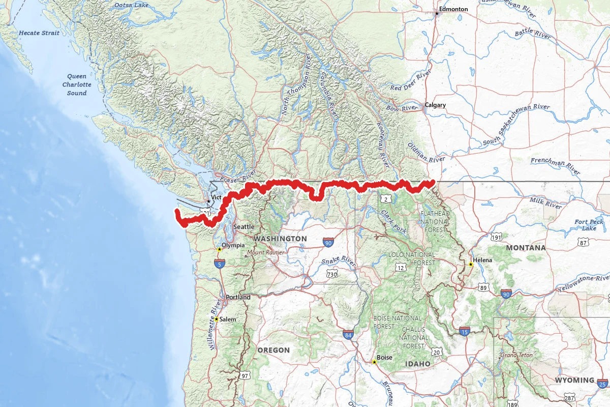
Pacific Northwest Trail
Thru-hike planner
Pacific Northwest Trail
1,200-mile thru-hike planner: permits, resupply and the places along the route

- Markers
- 179
- Resources
- 1
- Distance
- 1200.0 mi
- Elevation
- —
- Markers
- 179
- Resources
- 1
- Distance
- 1200.0 mi
- Elevation
- —
Notes
Permits and official resources
Straight from the agencies and the trail's managing association. Rules and permit systems change, so check these pages before you go.
Permits
- Glacier NP wilderness camping permit National Park Service
- North Cascades NP backcountry permits for PNT hikers National Park Service
- Olympic NP PNT thru-hiker zone permits National Park Service
- Pasayten Wilderness self-issue wilderness permit USDA Forest Service (Okanogan-Wenatchee NF)
- Glacier NP wilderness advance reservations (lottery and general on-sale) National Park Service
- Olympic NP Wilderness Information Center (permit review and pickup) National Park Service
Plan your hike
- PNT Passes and Permits USDA Forest Service
- About the PNT USDA Forest Service
- PNT FAQ Pacific Northwest Trail Association
- PNT camping, permits & fees Pacific Northwest Trail Association
- Olympic Wilderness Coast hiking (tides, canisters) National Park Service
- Olympic NP wilderness backpacking reservations National Park Service
- North Cascades NP backcountry reservations National Park Service
- PNT Trail Alerts and closure list (sign up for email alerts) Pacific Northwest Trail Association
- Free PNTA map set: strip maps, overview maps, resupply planner, permit guides Pacific Northwest Trail Association
- Trail towns and resupply planner (mileage to each town) Pacific Northwest Trail Association
- Directions and transportation (East Glacier, Ozette, Keystone Ferry, transit) Pacific Northwest Trail Association
- Challenges and risks: scrambling, bushwhacking, tides on the coast Pacific Northwest Trail Association
- Food storage on the PNT Pacific Northwest Trail Association
- Snow on the PNT (choosing a start date) Pacific Northwest Trail Association
- Guidebooks and references for the PNT Pacific Northwest Trail Association
Who to call
- Pacific Northwest Trail Association360-854-9415info@pnt.org209 Ferry Street, Suite A | Sedro-Woolley, Washington 98284
- Glacier National ParkNational Park Service(406) 888-7800glac_questions@nps.govPO Box 128 West Glacier, MT 59936
- Glacier NP wilderness permit staffNational Park Serviceglac_backcountry_permits@nps.gov
- Wilderness Information Center, North Cascades NPNational Park Service(360) 854-7245810 State Route 20 Sedro-Woolley, WA 98284
- Wilderness Information Center, North Cascades NP (PNT permits email)National Park Servicenoca_wilderness@nps.gov
- Wilderness Information Center, Olympic NPNational Park Service(360) 565-31003002 Mount Angeles Road, Port Angeles, WA 98362
Books for the trail
- PNTA strip maps (opens in new tab)Maps · Pacific Northwest Trail Association · Pacific Northwest Trail Association · revised annually; free downloadThe official, annually revised route maps: alternates, known bushwhacks, campsites, hazards and a resupply planner.
- Pacific Northwest Trail Digest (opens in new tab)Guidebook · Tim Youngbluth · Tim Youngbluth (listed by the PNTA) · 2022 edition listed; revised annuallyThe PNTA's guidebook page recommends choosing an annually revised guide, such as this one, because the trail corridor changes often; it carries trail tips and navigation notes, and the PNTA says it shares detailed water-source information.
- Pacific Northwest Trail Town Guide (opens in new tab)Guidebook · Melanie Simmerman · Melanie Simmerman (listed by the PNTA) · 2023 edition listedTown-by-town services and which businesses hold resupply packages, per the PNTA's resupply page.
- National Geographic Trail Illustrated Maps (opens in new tab)Maps · National Geographic · National Geographic · 215 Glacier/Waterton, 223 North Cascades, 216 OlympicLarger-area park maps the PNTA suggests to supplement its strip maps; they may not show popular PNT alternates.
- Pathfinder (opens in new tab)Narrative · Ron Strickland · Oregon State University Press · 2011 paperbackThe trail's founder on conceiving and establishing the PNT, setbacks and all.
- Grizzly Bears and Razor Clams (opens in new tab)Narrative · Chris Townsend · not stated on the PNTA pageA book about walking the PNT, listed by the PNTA under 'More Great Books on the PNT'.
Links go to the publisher or the trail association. Check for the current edition.
Checkpoints
- 1
Chief Mountain, Glacier National Park, MT
Mile zero for westbound hikers. The PNT's eastern terminus is the Belly River Trailhead near the Chief Mountain Port of Entry, and the trail drops straight into Glacier National Park. A wilderness permit is required for any overnight trip, and an advance reservation has to be picked up in person at a permit office before you go to the trailhead. PNTA names the Two Medicine Ranger Station and St. Mary Visitor Center as the convenient permit offices for an east-side start. Advance reservations are capped at 16 miles a day, and PNTA says the distance between campsites lets you cross the park in four or five days. Camping is only at designated sites, the largest party allowed is 12, and pets are not allowed on any trail in the park. PNTA notes that the seasonal suspension and plank bridges are not installed until mid-July. You start in grizzly country and stay in it: PNTA says about 400 miles of the PNT, from this terminus through eastern Washington, is grizzly habitat, and proper food storage is required.
- 2
Cape Alava, Olympic National Park, WA
The western terminus, at the westernmost point in the contiguous United States. It is three miles from the Ozette Ranger Station on boardwalk that can be extremely slick. The permit is the trap. Cape Alava is outside the North Coast PNT zone and must be booked on your permit as its own site. Camping is prohibited on the Ozette Indian Reservation, between Cape Alava and the south side of the Ozette River, and Cannonball Island is part of the reservation and always closed. There are toilets at the main group of campsites. The last miles in are a tide problem, not a mileage problem: the park and PNTA both record deaths on this coast from people trying to beat the tide.
1246 mi from start
Landmarks (2)
Markers (179)
Trails (1)
Reviews
No reviews yet
Be the first to share your experience and help others plan their visit.