Thru-hike planner
Mountains-to-Sea Trail
Thru-hike planner
Mountains-to-Sea Trail
1,175-mile thru-hike planner: permits, resupply and the places along the route
Shared by Outdoors Support
- Markers
- 134
- Resources
- 1
- Distance
- 1175.0 mi
- Elevation
- —
- Markers
- 134
- Resources
- 1
- Distance
- 1175.0 mi
- Elevation
- —
Notes
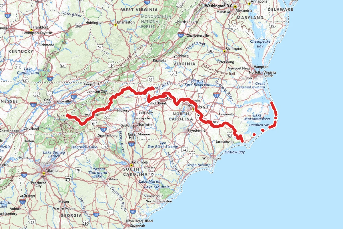
The Mountains-to-Sea Trail crosses North Carolina from Kuwohi, on the Tennessee line in Great Smoky Mountains National Park, to Jockey's Ridge State Park on the Outer Banks. Friends of the Mountains-to-Sea Trail give the route as 1,175 miles, but not all of that is footpath. Almost 725 miles are footpath. Temporary routes on back roads and bicycle paths connect the rest. It is an official state trail, and different agencies and local governments manage different parts. Allow three to four months. Spring and fall are the best seasons. For an early-year start, the Friends suggest hiking west from the coast so you reach the mountains after the snow and ice have melted. Snow is possible at high elevations as late as April. For a summer or fall start, begin at Kuwohi and head east as it cools. Friends says most hikers start at 10 to 12 miles a day. It asks thru-hikers to register before they start; registered hikers get the list of Trail Angels, and completers receive a certificate at the annual meeting.
Three places need an overnight permit. Great Smoky Mountains National Park requires a permit and advance reservations for all backcountry camping, and you can camp only at designated campsites and shelters. You book the Smokies permit on Recreation.gov. In the Linville Gorge Wilderness, on Segment 4, a Recreation.gov permit is needed to camp inside the Wilderness on Friday and Saturday nights from May through October, and on Sunday night of three-day holiday weekends. Only 50 people are permitted per night: 35 spaces open a month ahead, and 15 last-minute spaces open each Wednesday at 10 a.m. for the coming weekend. The Forest Service also limits a stay there to three consecutive days and two nights, and bans camping within 200 feet of the Gorge's trailhead parking areas. The Blue Ridge Parkway requires a Recreation.gov permit for overnight use of its primitive camping areas, and its backcountry rules prohibit camping outside the designated sites. The Friends' FAQ lists only the Smokies and Linville Gorge, so check the rest with each land manager. Stone Mountain State Park has four primitive backpack campsites on the Widow's Creek Trail. That trail is part of the MST, but the sites are down the left fork where the MST goes right. They have no facilities, and you need a reservation. On the Outer Banks, Cape Hatteras National Seashore allows camping only in designated campgrounds. Jockey's Ridge State Park, the eastern end, has no camping. The closest state park with camping is Pettigrew State Park. The MST has no system of campsites and shelters like the Appalachian Trail, and Friends does not condone illegal or stealth camping. Its segment guides list legal camping, and it has partnered with Hipcamp on a map of campsites within five miles of the trail. In the Pisgah and Nantahala national forests, a stay is limited to 14 days in 30, someone must occupy a new campsite the first night, and gear may not be left unattended for more than 24 hours.
The terrain changes a lot. Segment 1 has a 22.8-mile stretch with no road access. Segment 2 has almost 25,000 feet of climbing and descending in total. Segment 3 runs from about 2,000 feet at the French Broad River to over 6,600 feet on Mount Mitchell. Segment 4 is very remote, and the section down and out of Linville Gorge is strenuous. The Friends warn about bears in the mountains and on the coast, giardia, insects (especially on the coast), heat and cold illness, and hunting in areas where it is allowed, where you should wear blaze orange. Each segment guide has a hunting section, and Suggs Mill Pond Game Land closes on certain hunting days; Friends publishes a calendar of them. Loose dogs are occasionally a problem on road sections, and Friends says poles or bear spray can protect you if one attacks. The blaze is a three-inch white circle. Friends warns that many websites and apps show wrong or outdated routes for the MST, and that its segment guides count miles per segment, not for the whole trail.
Treat all your drinking water. In Linville Gorge, repeated fires have left stretches with little water or shade. The Smokies require food and other odorous items to be hung on the bear cable at each campsite or shelter. On the Parkway's backcountry sites, use a bear-proof container, a park bear box, or hang your food. In the Pisgah Ranger District, the Forest Service requires bear-resistant canisters for overnight campers around Graveyard Fields, Shining Rock Wilderness, Black Balsam, and Sam's Knob and Flat Laurel Creek. Camping is prohibited in the Graveyard Fields area.
The Friends list three ways to resupply: buy food at stores and gas stations along the route, mail boxes to a post office, or have family or friends meet you. Each segment guide lists the post offices near the trail. Post offices are usually open weekdays and closed on major holidays, so time your boxes. Segment 2 has virtually no resupply. Segment 7 has no towns or stores on it; the nearest are Pinnacle, Pilot Mountain, and King. Asheville is the trail community for Segment 3, and the Friends call it well worth a layover.
The road up to Kuwohi has seasonal closures and can close for snow and ice. The Friends keep a list of commercial shuttle services. Some cover Kuwohi to Stone Mountain State Park, and they know of none in the Piedmont. Trail Angels also give rides, and their list is open only to hikers registered with the Friends. The east end takes two ferries, Cedar Island to Ocracoke and Ocracoke to Hatteras Island. The state ferry division takes reservations up to 90 days ahead on Cedar Island to Ocracoke and recommends them. Hatteras to Ocracoke takes no reservations, and walkers do not need them. Friends lets completers be driven over the Marc Basnight Bridge on Segment 18, and walk parallel roads where Outer Banks beaches are closed for wildlife or impassable. You may also bike the road and paved greenway sections, paddle 27.5 miles of the Yadkin River between Elkin and Pilot Mountain State Park, or paddle the 170-mile Neuse River route from Smithfield to the Croatan, which brings the total down to 1,030 miles.
Dogs are welcome on most of the trail on a leash. Two places prohibit them: the Sauratown Trail, which is most of Segment 7, and Great Smoky Mountains National Park, which has kept dogs out of its backcountry since the 1930s. Friends' FAQ also names Pea Island National Wildlife Refuge. But the refuge's own page says leashed pets may go on its beach except in closed areas, including near Oregon Inlet. They are not allowed west of Highway 12 except in parking areas. If you leave a car in the Smokies, the park requires a parking tag for any vehicle parked longer than 15 minutes.
Hurricane Helene hit the western mountains in September 2024. Friends says almost all of the trail from Kuwohi to Stone Mountain State Park has reopened, but the bridge over the North Fork of the Catawba River in Segment 4 was destroyed. The river there is deep, with no safe crossing or walking detour, so that gap, from US 221 north of Marion to the west side of Linville Gorge, must be driven around. A second Segment 4 closure, near the Blue Ridge Parkway and NC 80, has a detour on busy roads that you may drive instead. Trail status can change. Before you go, read the Friends' Trail Updates page and their Helene recovery map. For national forest closures, use the Forest Service's North Carolina alerts. Check the Smokies and Blue Ridge Parkway sites for road closures.
Permits and official resources
Straight from the agencies and the trail's managing association. Rules and permit systems change, so check these pages before you go.
Permits
- Great Smoky Mountains backcountry permits (Recreation.gov) National Park Service
- Great Smoky Mountains backcountry camping rules National Park Service
- Linville Gorge Wilderness overnight permits (Recreation.gov) USDA Forest Service
- Blue Ridge Parkway backcountry camping permits National Park Service
- Linville Gorge no-camping zones at trailheads USDA Forest Service
- Stone Mountain State Park backpack campsite reservations North Carolina State Parks
Plan your hike
- The Mountains-to-Sea Trail Friends of the Mountains-to-Sea Trail
- Frequently asked questions Friends of the Mountains-to-Sea Trail
- Segment guides and FarOut Friends of the Mountains-to-Sea Trail
- Trail updates and closures Friends of the Mountains-to-Sea Trail
- Shuttle services Friends of the Mountains-to-Sea Trail
- Mountains-to-Sea State Trail North Carolina Division of Parks and Recreation
- National Forests in North Carolina alerts USDA Forest Service
- Pisgah bear canister requirement USDA Forest Service
- Blue Ridge Parkway alerts and conditions National Park Service
- Great Smoky Mountains cautions and closures National Park Service
- Ferry reservations (Cedar Island to Ocracoke) NC Department of Transportation
- Register your thru-hike and completion rules Friends of the Mountains-to-Sea Trail
- Hiker resources (guides, books, campsite map, trail angels) Friends of the Mountains-to-Sea Trail
- Trail Angels (list for registered hikers) Friends of the Mountains-to-Sea Trail
- Report trail issues Friends of the Mountains-to-Sea Trail
Who to call
- Friends of the Mountains-to-Sea Trail919.825.02973509 Haworth Drive, Suite 210 Raleigh, NC 27609
- Great Smoky Mountains Backcountry Information OfficeNational Park Service - Great Smoky Mountains National Park865-436-1297Backcountry office located in the Sugarlands Visitor Center
- Blue Ridge Parkway headquartersNational Park Service - Blue Ridge Parkway828 348-3400199 Hemphill Knob Rd Asheville, NC 28803
- National Forests in North Carolina Supervisor's OfficeUSDA Forest Service - National Forests in North Carolina828-257-4200160 Zillicoa St Suite A Asheville, NC 28801
- Grandfather Ranger District (Linville Gorge)USDA Forest Service - Pisgah National Forest(828) 652-2144
- Pisgah Ranger DistrictUSDA Forest Service - Pisgah National Forest(828) 866-34371600 Pisgah Highway Pisgah Forest , NC 28768
- Jockey's Ridge State Park visitor centerNorth Carolina State Parks(252) 573-6108
Books for the trail
- Mountains-to-Sea Trail Guides (opens in new tab)Guidebook · Friends of the Mountains-to-Sea Trail (Jim Grode, Trail Resource Manager) · Friends of the Mountains-to-Sea Trail · PDF segment guides, revised regularlyThe official segment guides: directions both ways, supplies, lodging, camping, food, water and trailhead coordinates for all 18 segments and the Neuse paddle route.
- Great Day Hikes on North Carolina’s Mountains-to-Sea Trail (opens in new tab)Guidebook · Friends of the Mountains-to-Sea Trail, edited by Jim GrodeThe association's official book of 40 hikes along the route; a way to scout sections before committing.
- Discovering North Carolina’s Mountains-to-Sea Trail: A Companion for Hikers and Armchair Explorers (opens in new tab)History · Jerry BarkerSegment-by-segment history and stories along the full route, by a former Friends president.
- The Mountains-to-Sea Trail Across North Carolina: Walking a Thousand Miles through Wildness, Culture and History (opens in new tab)Narrative · Danny Bernstein · The History Press · 2013A completer's account; Friends says it gives a great sense of the trail's highlights and challenges, though it is not a guide.
- MST Trail Profiles and Maps: From Clingmans Dome to Mount Mitchell and Beyond (opens in new tab)Maps · Walt Weber and the Carolina Mountain Club · Carolina Mountain Club · 3rd editionMaps and elevation profiles for about half the mountain miles.
Links go to the publisher or the trail association. Check for the current edition.
Landmarks (2)
Markers (134)
Trails (1)
Reviews
No reviews yet
Be the first to share your experience and help others plan their visit.