Thru-hike planner
Long Trail
Thru-hike planner
Long Trail
272-mile thru-hike planner: permits, resupply and the places along the route
Shared by Outdoors Support
- Markers
- 102
- Resources
- 1
- Distance
- 272.0 mi
- Elevation
- —
- Markers
- 102
- Resources
- 1
- Distance
- 272.0 mi
- Elevation
- —
Notes
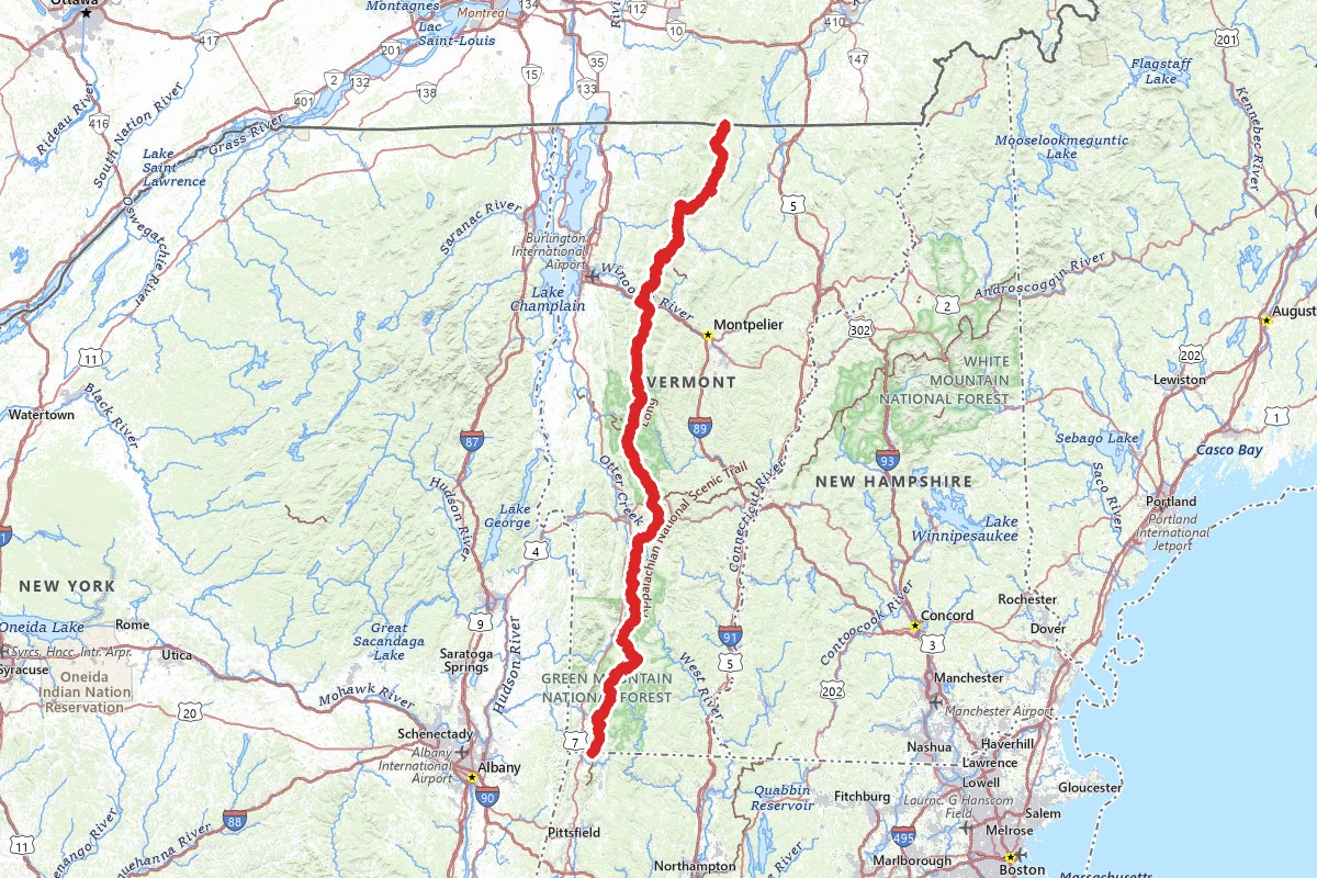
The Long Trail runs 272 miles along the spine of Vermont's Green Mountains, from the Massachusetts border to the Canadian border. The Green Mountain Club (GMC) looks after it. Volunteers built it between 1910 and 1930, and GMC calls it the oldest long-distance hiking trail in the United States. The southern part of the trail is co-located with the Appalachian Trail, so it is often busier. The average thru-hike takes 20 to 30 days, including a few zero or nero days in town. Most people walk north, which starts with gentler terrain. Southbound works too, with fewer people at first and steeper, rougher ground right away. GMC recommends starting in July, August or September. June is popular, but snow can linger in the mountains and black flies are at their worst. October through March counts as winter in the mountains, and GMC does not recommend a thru-hike then.
Individual hikers do not need a permit. The whole system is free and open to the public. Some groups may need a special-use permit from Green Mountain National Forest or from Vermont Forests, Parks and Recreation. The national forest covers the trail from the Massachusetts border to Mt. Ellen, except Cooper Lodge. From Mt. Ellen to Canada it is Vermont state land. On the national forest, a Forest Order bars camping more than two nights in a row at any shelter. April and May are mud season. GMC discourages high-elevation hiking then, and hikers stay off high-elevation trails until they dry out, typically by Memorial Day. GMC and Vermont Forests, Parks and Recreation issue closures weekly during the thaw.
Neither end is at a road. The southern terminus is on the Massachusetts line, and you reach it from North Adams or Williamstown on either the Pine Cobble Approach Trail or the Appalachian Trail. The northern terminus is at the Canadian border, and walking out adds 1.3 miles on the Journey's End Trail. Long-term parking is possible at both ends, but many hikers arrange a shuttle. The GMC Visitor Center keeps a list of volunteer trail angels and shuttle drivers and gives free advice on logistics. You can call it at 802-244-7037. Hitchhiking into town is common, but it is your call. The trail crosses many major roads, and most have parking at the trailhead. Do not leave valuables in your car.
Expect rocks, roots, mud and steep climbs, especially in the northern half of the state. The trail crosses all five Vermont peaks over 4,000 feet, including Mount Mansfield, the highest in the state. Volunteers took the shortest, steepest line from valley to summit, and the trail still has that reputation. Weather often causes the most likely threats to your safety. Rain, fog, wind and sharp temperature drops can come at any time, even in summer, and the ridges can run as much as 5 degrees Fahrenheit colder per 1,000 feet. Carry warm layers and rain gear. Most crossings have a bridge or are mild flows, but even mild streams can become unsafe after prolonged or heavy rain. When in doubt, wait it out. Ticks are present. Help may be many hours away. If you need it, call 911. Vermont does not charge for search and rescue. On Mansfield, Camel's Hump and Mt. Abraham, stay on the marked trail or bare rock to protect the alpine plants. GMC strongly prefers a paper map and compass, because phones die.
The trail has 70 free, first-come, first-served overnight sites, from tent areas to lean-tos to lodges with bunks, roughly every 5 to 10 miles. Each has a privy and an untreated water source. Caretaker-staffed sites run on donations. Many shelters, though not all, have room for a tent nearby, but tenting is not allowed above 2,500 feet. Some sites allow a fire in a communal firepit and others ban fires. GMC says to carry a tent or hammock even if you plan to use shelters, and to have alternative overnight options. Water sources can fail in dry weather, and GMC strongly recommends treating all water. For detail on water sources, GMC points to the Long Trail Guide.
Bear-safe food storage is required in Green Mountain National Forest. Food, containers and trash must be stored in a closed motor vehicle or hung at least 12 feet above the ground and 6 feet from any object. Bear boxes and bear canisters are also acceptable. GMC prefers canisters and lends them for free, first come, first served. Ursacks and hangs are allowed, but good hanging trees are hard to find. About a dozen shelters have bear boxes, but they fill up, so bring your own method. Never put food or trash in a privy, and never sleep with your food or hang it inside a shelter.
Many hikers carry three to five days of food and resupply a few times. You can buy at local stores or mail boxes to post offices and trail-friendly businesses, which will hold them for you. Do not cache food along the trail on the national forest: unattended food, caches and resupplies are removed. GMC lists Bennington, Manchester, Killington and Rutland, Waitsfield, Waterbury, Stowe and Johnson as common resupply towns. GMC's free digital End-to-Ender's Guide lists stores, hostels, post offices and laundromats.
For current conditions, check GMC's Trail Updates page and the Green Mountain National Forest alerts page. GMC has moved the trail off the cliff at Prospect Rock in Johnson and onto a new line north of Route 118 on Belvidere Mountain, so use a current map. Have a way to get weather forecasts and emergency alerts while you hike, such as VT-ALERT. When you finish, GMC certifies End-to-Enders for free.
Permits and official resources
Straight from the agencies and the trail's managing association. Rules and permit systems change, so check these pages before you go.
Permits
- Green Mountain National Forest special use permits (groups) USDA Forest Service
- Vermont state lands special use permit / license application (groups) Vermont Department of Forests, Parks and Recreation
Plan your hike
- The Long Trail Green Mountain Club
- Mud season Green Mountain Club
- Hiking in groups (permit requirements) Green Mountain Club
- Food storage regulations Green Mountain Club
- Food storage restrictions, Green Mountain National Forest USDA Forest Service
- Safe water crossing techniques on the Long Trail Green Mountain Club
- Green Mountain and Finger Lakes National Forests recreation USDA Forest Service
- Thru-hiking the Long Trail (planning page) Green Mountain Club
- Trail updates and alerts Green Mountain Club
- Green Mountain National Forest alerts and closures USDA Forest Service — Green Mountain National Forest
- Forest Order: two-night limit at AT/LT shelters USDA Forest Service — Green Mountain National Forest
- Trail magic and caches on the national forest Green Mountain Club
- Free End-to-Ender's Guide (towns, lodging, resupply) Green Mountain Club
- End-to-Ender certification Green Mountain Club
- Staying safe: ten essentials, weather, search and rescue Green Mountain Club
Who to call
- Green Mountain Club (headquarters and visitor center)Green Mountain Club802-244-70374711 Waterbury-Stowe Road Waterbury Center, Vermont 05677
- Green Mountain and Finger Lakes National Forests Supervisor's OfficeUSDA Forest Service — Green Mountain National Forest(802) 747-67004387 U.S. Route 4 East Mendon, VT 05701
- GMNF special-use permit applications (Public Services Staff Officer)USDA Forest Service — Green Mountain National Forest(802)747-6724
- Manchester Ranger Station, Green Mountain NFUSDA Forest Service — Green Mountain National Forest(802) 362-23072538 Depot Street Manchester Center, VT 05255
- Rochester Ranger Station, Green Mountain NFUSDA Forest Service — Green Mountain National Forest(802) 767-426199 Ranger Road Rochester, VT 05767
- Vermont Department of Forests, Parks and Recreation (general inquiries)Vermont Department of Forests, Parks and Recreation802-828-1531anr.forests@vermont.gov
- Vermont State ParksVermont Department of Forests, Parks and Recreation1-888-409-7579parks@vermont.gov
Books for the trail
- Long Trail Guide (opens in new tab)Guidebook · Green Mountain Club · Green Mountain Club · 29th EditionThe club's own trail-by-trail guide to the 272-mile Long Trail, its side trails and the AT in Vermont, with full-color maps; GMC points to it for water sources and overnight-site rules.
- Long Trail Map (opens in new tab)Maps · Green Mountain Club · Green Mountain Club · 7th edition (2025), waterproof; digital version on AvenzaWaterproof map with shelter locations, mileages between points and elevation profiles; GMC says to always carry a paper map because phones die.
- End-to-Ender's Guide (opens in new tab)Data book · Green Mountain Club · Green Mountain Club · 2026 (free download)Free town guide for a thru-hike: getting to and from the trail, lodging, resupply, laundry and meals, with no paid listings.
- Nature Guide to Vermont's Long Trail (opens in new tab)Guidebook · Lexi Shear · Green Mountain ClubWalks the length of the trail naming its natural communities and 215 plant and animal species with photos.
- So Clear, So Cool, So Grand (opens in new tab)Narrative · James Gordon Hindes (edited by Reidun Nuquist) · Green Mountain ClubOne of the first accounts of a Long Trail end-to-end hike, from 1931.
- A Century of Long Trail Guidebooks (opens in new tab)History · Reidun Nuquist · Green Mountain Club · RetrospectiveHistory of the trail told through a century of GMC's guidebook editions.
Links go to the publisher or the trail association. Check for the current edition.
Landmarks (37)
Markers (102)
Trails (1)
Reviews
No reviews yet
Be the first to share your experience and help others plan their visit.