Thru-hike planner
Long Path
Thru-hike planner
Long Path
Thru-hike planner: permits, resupply and the places along the route

- Markers
- 86
- Resources
- 1
- Distance
- 358.0 mi
- Elevation
- —
- Markers
- 86
- Resources
- 1
- Distance
- 358.0 mi
- Elevation
- —
Notes
Permits and official resources
Straight from the agencies and the trail's managing association. Rules and permit systems change, so check these pages before you go.
Permits
- Primitive camping rules and Forest Ranger permits New York State Department of Environmental Conservation
- State land camping rules New York State Department of Environmental Conservation
- Sundown Wild Forest and Peekamoose Valley camping permits New York State Department of Environmental Conservation
- Peekamoose Blue Hole and riparian corridor permit New York State Department of Environmental Conservation
Plan your hike
- The Long Path New York-New Jersey Trail Conference
- Backpacking the Long Path New York-New Jersey Trail Conference
- End-to-End section guide New York-New Jersey Trail Conference
- Navigating the Long Path New York-New Jersey Trail Conference
- Trail alerts New York-New Jersey Trail Conference
- Catskill backcountry information New York State Department of Environmental Conservation
- Spring recreation tips (mud season and high water) New York State Department of Environmental Conservation
- Hike Smart NY New York State Department of Environmental Conservation
- Hunting and trapping seasons New York State Department of Environmental Conservation
- Harriman State Park New York State Parks
- Minnewaska State Park Preserve (Sam's Point Area) New York State Parks
- John Boyd Thacher State Park New York State Parks
- Interactive Long Path map (current route, seasonal and high-water routes) New York-New Jersey Trail Conference
- Long Path history New York-New Jersey Trail Conference
- Section 20: Phoenicia to Silver Hollow Notch (start of the 40-mile resupply gap) New York-New Jersey Trail Conference
Who to call
- New York-New Jersey Trail Conference(201) 512-9348600 Ramapo Valley Rd Mahwah, NJ 07430-1199
- DEC Forest Ranger Dispatch (emergencies)New York State Department of Environmental Conservation833-697-7264
- DEC Forest Rangers (camping permits, local ranger contact)New York State Department of Environmental Conservation518-897-1300
- DEC Region 3 (Lower Hudson Valley, southern Catskills)New York State Department of Environmental Conservation845-256-307621 S Putt Cors New Paltz, NY 12561
- DEC Region 4 Stamford office (northern Catskills)New York State Department of Environmental Conservation607-652-736565561 State Highway 10 Suite 1 Stamford, NY 12167
- Catskills Visitor CenterNew York State Department of Environmental Conservation845-688-3369
- Harriman State ParkNew York State Parks(845) 947-2444
- Minnewaska State Park PreserveNew York State Parks(845) 255-07525281 Route 44-55 Kerhonkson, NY 12446
- John Boyd Thacher State ParkNew York State Parks(518) 872-1237830 Thacher Park Road Voorheesville, NY 12186
Books for the trail
- Hudson Palisades Trails Map (opens in new tab)Maps · New York-New Jersey Trail Conference · New York-New Jersey Trail Conference · 2023, 7th edition (five-map set, Tyvek)Covers 40 miles of the Long Path along the Palisades on waterproof Tyvek.
- West Hudson Trails Map (opens in new tab)Maps · New York-New Jersey Trail Conference · New York-New Jersey Trail Conference · 2019, 8th edition (two-map set, Tyvek)Covers the Orange County parklands west of the Hudson (Schunemunk, Storm King, Black Rock Forest); the store lists more than 10 miles of the Long Path on it.
- Harriman-Bear Mountain Trails Map (opens in new tab)Maps · New York-New Jersey Trail Conference · New York-New Jersey Trail Conference · 2023, 20th edition (two-map set, Tyvek)Covers the Long Path's three Harriman sections, including Section 7, which the Trail Conference calls by far the most rugged of the three.
- Shawangunk Trails Map (opens in new tab)Maps · New York-New Jersey Trail Conference · New York-New Jersey Trail Conference · 2023, 12th edition (three-map set, Tyvek)Covers the Sam's Point and Minnewaska stretch; its 2023 update includes Long Path changes after forest fires.
- Catskill Trails Map (opens in new tab)Maps · New York-New Jersey Trail Conference · New York-New Jersey Trail Conference · 2023, 13th edition (six-map set, Tyvek)The section guide cites these maps for the Catskill sections, where the Long Path follows Forest Preserve trails with their own disk colors.
- Catskill Trails Guide (opens in new tab)Guidebook · Tom Rankin (editor) · Adirondack Mountain Club (sold by the Trail Conference) · 2023, 5th editionTrail-by-trail descriptions, rules, parking and mileages for Catskill Park, where the Long Path runs on existing Forest Preserve trails.
- Harriman Trails (opens in new tab)Guidebook · William J. Myles and Daniel Chazin · New York-New Jersey Trail Conference · 2018, 4th editionGuide and history of Harriman's trails, updated for relocations of the Long Path.
Links go to the publisher or the trail association. Check for the current edition.
Checkpoints
- 1
175th Street subway station, NYC
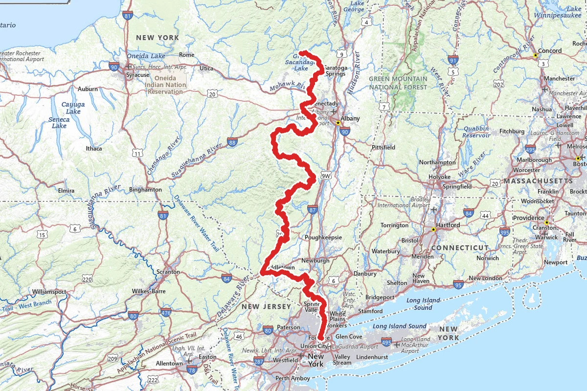
Mile zero. The Long Path starts at the 175th Street station on the A train in Washington Heights. From the Fort Washington Avenue exit, head north, turn left on W 178th Street, and take the pedestrian Southwalk across the George Washington Bridge into New Jersey. The first 14 miles follow the top of the Palisades between the cliff edge and the Palisades Interstate Parkway, and the Parkway is within earshot most of the way. There is no camping on this section, so plan your first night indoors. Plan the whole trip that way. The Trail Conference says you can't camp along the trail for its entire length, so some nights mean walking to a motel or a campground. Carry a tent anyway: outside the Appalachian Trail stretch and the Catskills, shelters are rare.
- 2
Altamont, NY (near John Boyd Thacher State Park)
The end-to-end finish. Since a 2025 relocation, the Long Path comes down off the Helderberg Escarpment on a new footpath and a short road walk, and ends at Orsini Park in the Village of Altamont. That is the official terminus for End-to-End hikers. The blazes keep going. The trail is marked across the Mohawk River to the Saratoga County line, and a route is described from there to the Adirondack Park boundary, but until more of that route is off-road those sections are not required for the certificate. Altamont has street parking along Main Street and signed lots off Main and Maple. A Stewart's gas station and convenience store sits at the junction of Route 156, Main Street and Altamont Boulevard, just before the park.
Landmarks (77)
Markers (86)
Trails (1)
Reviews
No reviews yet
Be the first to share your experience and help others plan their visit.