Thru-hike planner
Ice Age National Scenic Trail
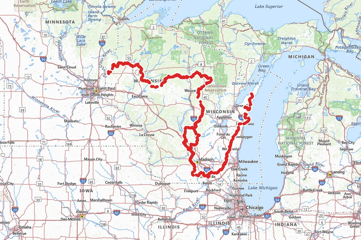
Thru-hike planner
Ice Age National Scenic Trail
1,200-mile thru-hike planner: permits, resupply and the places along the route

- Markers
- 160
- Resources
- 1
- Distance
- 1200.0 mi
- Elevation
- —
- Markers
- 160
- Resources
- 1
- Distance
- 1200.0 mi
- Elevation
- —
Notes
Permits and official resources
Straight from the agencies and the trail's managing association. Rules and permit systems change, so check these pages before you go.
Permits
- Fees and permits along the trail (NPS) National Park Service
- Reservable backpack camping (Wisconsin State Park System) Wisconsin DNR
- Kettle Moraine Northern Unit camping and backpack shelters Wisconsin DNR
- Backpacking camping options and rules Ice Age Trail Alliance
Plan your hike
- Basic information National Park Service
- Alerts and conditions National Park Service
- Safety National Park Service
- Frequently asked questions National Park Service
- Section and thru hiking Ice Age Trail Alliance
- Thousand-Miler FAQ Ice Age Trail Alliance
- Hiker resources: maps, alerts, guidebooks Ice Age Trail Alliance
- More resources: post offices, closures list, guidebook updates Ice Age Trail Alliance
- Hunting season and the Ice Age Trail Ice Age Trail Alliance
- Volunteer chapters (free shuttles) Ice Age Trail Alliance
- Ice Age National Scenic Trail (state parks and forests on the route) Wisconsin DNR
- Dogs on the Ice Age Trail (leash rule, segments where dogs are prohibited) Ice Age Trail Alliance
- Plan a hike: private-land etiquette, safety, what to wear Ice Age Trail Alliance
- Backpacking: the four kinds of camping and dispersed camping area rules Ice Age Trail Alliance
- Guidebook, Atlas and maps (Alliance store) Ice Age Trail Alliance
Who to call
- Ice Age National Scenic Trail (NPS administrative office)National Park Service608-798-87008075 Old Sauk Pass Road Cross Plains, WI 53528
- Ice Age Trail Alliance(800) 227-0046PO Box 128 2110 Main Street Cross Plains, WI 53528
- Wisconsin State Park System reservations (backpack shelters)Wisconsin DNR1-888-947-2757
Books for the trail
- Ice Age National Scenic Trail Guidebook (opens in new tab)Guidebook · Ice Age Trail Alliance · Ice Age Trail Alliance · 2026 (print with e-version, or e-version only)The official segment-by-segment guide, which lists each segment's specific regulations, including dog rules.
- Ice Age National Scenic Trail Atlas (opens in new tab)Maps · Ice Age Trail Alliance · Ice Age Trail Alliance · 2026 (print with e-version)Maps of the whole route including connecting roads, with water sources, restrooms, camping and where primitive camping is allowed.
- Geology of the Ice Age National Scenic Trail (opens in new tab)Guidebook · David M. Mickelson, Louis J. Maher, Jr., and Susan L. Simpson · University of Wisconsin Press · 2011Explains the glacial landforms along the trail (end moraines, kettles, eskers, drumlins), with trail descriptions cross-referenced to its science briefs.
- Thousand-Miler: Adventures Hiking the Ice Age Trail (opens in new tab)Narrative · Melanie Radzicki McManus · not stated on the Alliance page (sold through the author)A thru-hike account the Alliance sells, woven with trail history and strategies for a successful thru-hike.
Links go to the publisher or the trail association. Check for the current edition.
Checkpoints
- 1
Potawatomi State Park, Sturgeon Bay, WI
The eastern end of the Ice Age Trail. DNR puts the terminus inside Potawatomi State Park near the site of the old ski hill overlook, and there is parking at the overlook. You can start or finish the whole trail here, or walk the 2.8-mile stretch inside the park as a day hike. Heading west, the trail leaves the park off Shoreline Road and continues into the town of Sturgeon Bay. The park requires a state vehicle admission sticker for any car you leave here, and the gates are open 6 a.m. to 11 p.m.
- 2
Interstate State Park, St. Croix Falls, WI
The western end of the Ice Age Trail, above the St. Croix River and the Dalles gorge in Interstate State Park, Wisconsin's oldest state park. The terminus sits near the park's glacial potholes, and DNR puts it a half-mile from the Ice Age Interpretive Center. A state vehicle admission sticker is required to park, though the park is part of the Ice Age National Scientific Reserve and certain federal entrance passes are honored. The park is open 6 a.m. to 11 p.m. year-round. Heading east, the Trap Rock Chapter lists the 9-mile St. Croix Falls Segment first and the 15.5-mile Gandy Dancer Segment after it. The chapter also warns that much of the trail in Polk County is remote and finding water can be a problem in summer.
Landmarks (1)
Markers (160)
Trails (1)
Reviews
No reviews yet
Be the first to share your experience and help others plan their visit.