
Thru-hike planner

Florida National Scenic Trail
Cover photo for Florida National Scenic Trail

Thru-hike planner

Florida National Scenic Trail

1,500-mile thru-hike planner: permits, resupply and the places along the route

Shared by
Outdoors Support
Outdoors Support
Markers
130
Resources
1
Distance
1500.0 mi
Elevation
—

Notes

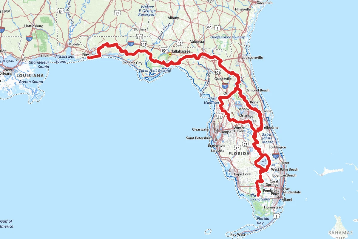
The Florida National Scenic Trail runs from Big Cypress National Preserve in the south to Gulf Islands National Seashore at the western end of the Panhandle. The Forest Service administers it. Volunteers of the Florida Trail Association created and improved it and still look after it. The Forest Service says it is about 1,500 miles long, and the association says about 1,000 of those miles are true trail and the rest is road walks and gaps. That total counts both corridors around greater Orlando, where the trail splits into Eastern and Western routes that rejoin behind the 88 Store just south of CR 316. A thru-hike follows one of them: the association puts an Eastern Corridor thru-hike at 1,287.9 miles, with 365.71 miles of road walks, and a Western Corridor thru-hike at 1,286.63 miles. Neither figure counts the 48.6-mile Blackwater Side Trail in the Panhandle. A typical thru-hiker takes two to three months. Hiking season runs roughly late October through April. The association recommends starting in the south in early January and finishing in the north by April. That timing avoids almost all general gun hunting restrictions and keeps you in the dry winter season. Permits are required on public lands at four places along the trail: the Seminole Reservation, St. Marks National Wildlife Refuge, Eglin Air Force Base and Camp Blanding. There is no single trail-wide permit. Seminole Reservation: you need permission to cross. Print the General Release and Covenant Not to Sue, sign it, have it notarized, and upload a copy to the online permit request form in the association's thru-hiker guide. The release is written for Florida Trail Association members. Carry a copy of your completed form through the Reservation. You cannot camp there, so you walk straight through. St. Marks: you need a written permit before you enter, there is a fee for each campsite you use, and only people hiking the whole refuge may camp. It is the only national wildlife refuge that lets hikers camp, and only Florida Trail thru and section hikers. The Fish and Wildlife Service keeps the refuge's hiker information, permit and map together in one collection. Eglin Air Force Base: the permit rule covers thru-hikers, meaning hikers whose journey starts more than 50 miles outside the base boundary. Contact Jackson Guard for special permitting. Every hiker must check the Public Access Map each day for mission closures. Eglin is an active weapons testing range, and the association's volunteers say the rumbles you hear there are rarely thunder. Camp Blanding: a permit is required. Make a free iSportsman account on the Camp Blanding site and follow the steps there. Civilians and Department of Defense dependents must pass a background check before they can get the permit. The gate code comes when you check in on the iSportsman site. Camping is not allowed anywhere on Camp Blanding property, and the base enforces this strictly. Big Cypress is where the sources disagree. The National Park Service manages the preserve, and its Basic Information page says backcountry hiking and camping require permits, with no fee. The Florida Trail Association has posted a notice saying backcountry permits are no longer required there. Neither is safe to assume. Ask the preserve which applies before you go, and carry any permit it tells you to carry. The association also asks hikers to sign the hiker logs at Oasis and the I-75 trailhead. Many campsites also need reservations made online ahead of time, including all the free South Florida Water Management District sites and, outside hunting periods, the Green Swamp sites. Spring Hammock Camp is open only to Florida Trail hikers and needs a reservation. On the Cross Florida Greenway, call ahead to say when you will arrive and which sites you plan to use. Fort Pickens campsites at the northern end must be reserved in advance. Many land managers know a thru-hiker cannot give exact dates and let you update a reservation. In Pine Log State Forest during hunting dates, the fee campground is the only legal camping. On the canal levees south of Lake Okeechobee, camping is allowed only at two designated campsites, STA 5/6 and L1-E, and both need a free permit from the South Florida Water Management District. The association also asks thru-hikers to tell its office at least 30 days before starting. It keeps a roster of end-to-end hikers: pre-register on its form, and after you finish, apply to be added and receive the official end-to-end certificate. Its Complete Thru Hiker Guide, linked from its Thru Hike page, gathers the required reservation and permit information and a section on Buckman's Lock. Hunting changes where you can sleep. General gun season, which the association calls the only truly problematic one for hikers, usually falls between November and January. In the Osceola National Forest, from mid-November to early January all camping is restricted to designated hunt camps and Ocean Pond Campground. In the Ocala National Forest you may camp anywhere outside hunting season, but during it you must stay at designated campsites. During general gun season, wear blaze orange and camp only at designated campsites. In Big Cypress the Park Service recommends a blaze orange vest in the backcountry during any hunting season. Look up hunting dates with the Florida Fish and Wildlife Conservation Commission. The hard parts are wet and rough. The association names marl mud and deep water in Big Cypress, eight miles of swamp forest in Bradwell Bay, rough limerock and grass on the South Florida dikes, and soft sand in the Ocala National Forest. There is no climbing. In Big Cypress the Park Service says water on the trail can be as deep as 3 to 4 feet, and in places waist deep in the wet season; from November through March you can usually expect to walk through some. There is private property inside the Big Cypress backcountry, so do not trespass. The association calls Bradwell Bay wet and rough and does not recommend it for first-time hikers; if the ditches along Forest Roads 329 and 314 are dry, expect only short wading. Near Rodman Reservoir the trail may be knee-deep when the rivers are high, and parts of the 71-mile Suwannee River section can be very wet or impassable at high water. In swamps it is easy to lose the trail, because in a hydric hammock every tree looks the same; keep watching for the next blaze. Parts of the trail flood quickly after heavy rain. Check river levels on the Kissimmee, Suwannee and other rivers the association lists, and do not hike the Suwannee at flood stage. On Eglin, the Big Fork Creek floodplain often floods after heavy rain; do not cross if it looks dangerous. South of Lake Okeechobee there is almost no shade. Heat exhaustion is a major concern, the association says to expect anything from 20 to 80 degrees in the winter season, and frost is possible in February, so the association suggests a 20°F sleeping bag for the winter months. Hurricane season runs June 1 to November 30, and storms can fall outside it, so check for closures after one passes. Most prescribed fires are set in winter and early spring. Road walks are part of the trip. The Park Service notes that several portions of the trail follow highways, up to 40 miles or more depending on the route you choose, and much of the Chipola section in the Panhandle is still road walk. Treat all surface water unless a sign says it is safe to drink. Water at St. Marks turns brackish at high tide. In Big Cypress the dry season can leave little or no water on the trail, so carry what you need; the Park Service recommends one gallon per person per day. In the Big Cypress Addition Lands, campsite water is standing and seasonal and may dry up. On the levees south of Lake Okeechobee the canals hold water the whole way, but it can be poor from farm runoff; the association says to filter before boiling. In the Ocala National Forest north of SR 40, surface water is only in scattered flatwoods ponds. Bring a stove, because campfires are banned on some sections. There are only seven hiker shelters on the whole trail, so carry a tent, bivy or hammock; the association recommends no-see-um netting. Rules on dogs differ by land manager, so check with each one before bringing a dog. All three national forests in Florida require food and garbage to be kept in bear-resistant containers or hard-sided vehicles, or hung at least 10 feet above the ground. Bear canisters can be rented free at Juniper Springs in the Ocala National Forest, with a refundable deposit. Carry paper. The Forest Service says many places along the trail have no phone reception, so bring a hard-copy map. A double blaze does not always show which way to turn; in general you should be able to see the next blaze from where you stand. The association updates its official map set and Data Book by October 1 each year, and the maps list the sheriff and land manager contacts for each area. In an emergency call 9-1-1 first. Resupply is done in towns near the trail. The association lists Clewiston, Okeechobee, Lake Butler, Keystone Heights, Palatka, Crestview, Blountstown and others as gateway communities for resupply, lodging or both. Okeechobee has a Publix and a Walmart and suits a big resupply. Lake Butler is the rough halfway point of an end-to-end hike, and its City Hall has a hiker resupply box. The Ace Hardware in Keystone Heights sells fuel canisters. Palatka has an Amtrak station and a municipal airport. Blountstown has a post office and motels, and Sopchoppy, just under four miles west of the trail, has a grocery and a city park where hikers camp. The northern end is at the Fort Pickens parking lot in Gulf Islands National Seashore, just south of Pensacola. The Fort Pickens area charges an entrance fee and does not allow overnight parking at any time of year, so do not plan to leave a car there. Its entrance station opens at 5 a.m. and closes at 8 p.m. from March through October and at 6 p.m. from November through February, and the Pensacola Bay City Ferry runs to Fort Pickens seasonally, March through October. A backcountry campsite sits in the seashore's Dunes Trail area facing Santa Rosa Sound. The southern end is in Big Cypress National Preserve. The Park Service and the association's region page put it at the Oasis Visitor Center on the Tamiami Trail (US 41); the association's FAQ places the southern terminus on Loop Road (SR 94), reached from the Tamiami Trail. Ask which start is meant before you arrange a ride. Conditions change. Check the Florida Trail Association's Trail Closures and Notices page and the Forest Service alerts page for the trail. The association warns that sudden closures may not show up on its page, so also contact the land manager for each section you plan to hike.

Permits and official resources

Straight from the agencies and the trail's managing association. Rules and permit systems change, so check these pages before you go.

Who to call

Books for the trail

Links go to the publisher or the trail association. Check for the current edition.

Full Florida National Scenic Trail guide

Checkpoints

  1. 1

    Big Cypress National Preserve - Oasis Visitor Center

    The Florida Trail's southern terminus is here, at the Oasis Visitor Center on the Tamiami Trail. The Park Service says the trail runs about 36 miles north from here to the Preserve's northern border. Sign the hiker log before you set off, and ask the rangers what the water is doing. Sources disagree on permits. The Park Service's Basic Information page says backcountry hiking and camping require a permit, with no fee; the Florida Trail Association says backcountry permits are no longer required. Ask at the desk before you set off. Plan for water both ways. In the wet season the Park Service says you may wade water that is waist deep in places, and portions of the trail can be under 3 to 4 feet of water at certain times of year; in the dry season (November to April) there may be little or no water along the trail, so pack in your own. Pets are not allowed on the Preserve's hiking trails or in the backcountry.

  2. 2

    Fort Pickens, Gulf Islands National Seashore

    This is the northern end of the Florida Trail, at historic Fort Pickens in Gulf Islands National Seashore. The Association calls the seashore the only National Scenic Trail beach hike in the nation, and the first miles are a walk on white quartz sand beside the Gulf. Campsites at Fort Pickens have to be reserved in advance, online or by phone. Overnight parking is not allowed at any time of year, so arrange a drop-off rather than leaving a car. The area charges an entrance fee and takes credit cards only. Pets are not allowed on the beach. After storms, check the Association's Trail Closures and Notices page before you start.

Markers (130)

Trails (1)

Reviews

No reviews yet

Be the first to share your experience and help others plan their visit.