Thru-hike planner
Continental Divide Trail
Thru-hike planner
Continental Divide Trail
3,100-mile thru-hike planner: permits, resupply and the places along the route
Shared by Outdoors Support
- Markers
- 460
- Resources
- 1
- Distance
- 3100.0 mi
- Elevation
- —
- Markers
- 460
- Resources
- 1
- Distance
- 3100.0 mi
- Elevation
- —
Notes
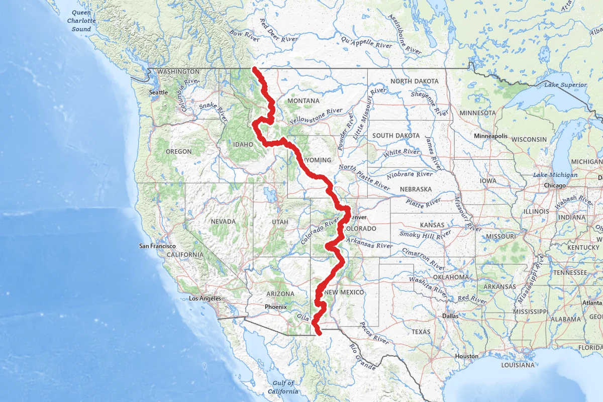
The Continental Divide Trail runs some 3,100 miles from the Mexican border to the Canadian border. It crosses New Mexico, Colorado and Wyoming, follows the Idaho-Montana line, then ends in Montana. About 95 percent of it is on public land run by the Forest Service, the Park Service or the Bureau of Land Management. A thru-hike can take 5 to 7 months. You can register a hike with the Continental Divide Trail Coalition as northbound, southbound or flip-flop, but registration is not a permit and does not replace one. Snow sets the calendar. The Forest Service says most thru-hikers start at the Mexican border so they don't hit Montana's deep spring snow. Colorado is normally snow-covered through May, and in places well into June. Idaho and Montana are best from July to early September.
No single permit covers the whole trail. You get each permit for each area you cross. A full-length hiker needs at least three: a Blackfeet Nation recreation permit, a Glacier National Park wilderness permit and a Yellowstone backcountry permit. The Coalition says Rocky Mountain National Park and the Indian Peaks Wilderness require permits if you camp there. Indian Peaks overnight permits are required in its summer season. New Mexico state trust land needs a recreational access permit. Some wilderness kiosks issue free self-service permits that can't be applied for in advance.
About 110 miles of the trail are in Glacier. The park's permit covers overnight camping on that stretch and on the whole Chief Mountain route, and you must use designated campsites. Some of Glacier's permits can be reserved in advance and some are held for walk-ins. Walk-up permits may be available the day before or the day of your start, and up to four people can share one. You can try at any open permit office. The Coalition says Two Medicine Ranger Station, on the trail about 20 minutes' drive from East Glacier, is the most popular one with CDT hikers. The Waterton Lakes Visitor Centre issues no walk-ups. People on trips of four or more nights can take walk-up sites well in advance, so arrive early the day before your start and bring your whole party. If you are starting in Glacier, the Coalition suggests checking its registration chart and picking a start date with fewer registrants. Yellowstone permits are picked up in person in peak season. A Recreation.gov reservation is not a Yellowstone permit.
The southern end has its own rule. The last 1.1 miles of trail, the Crazy Cook monument and parts of the access roads sit inside the New Mexico National Defense Area. You need permission from the Army at Fort Huachuca to enter it, so apply early.
Carry a map. Where the trail crosses BLM land in New Mexico it usually has no tread. Away from ranch roads it is marked by line-of-sight signs or rock cairns. The Coalition's free map set covers the official route at 1 inch to half a mile, with water sources and waypoints, and it publishes the route as GPX and KMZ files. Some sections cross state trust land or private property on easements. Stay on the trail and close gates behind you.
Colorado is high. Much of the trail there is above 10,000 feet, and the highest point is Grays Peak at 14,270 feet. Just north of New Mexico, the Weminuche Wilderness is a 100-mile section known for being rugged and isolated. The Coalition tells anyone unfamiliar with snow travel, especially in avalanche terrain, to stay out of Colorado until melt-out in June or July, and again once snow returns in September or October. In July and August, thunderstorms usually build between noon and 3 PM, and much of the route is above treeline. In Wyoming, snow can sit on the Wind River passes into July. In Yellowstone, passes can stay snow-covered until late July. Some river crossings there are 3 to 5 feet deep and extremely cold in late-spring runoff. Off-trail travel in Yellowstone's thermal areas is not allowed, and mosquitoes and biting flies can be intense.
New Mexico's bootheel is hot and dry, with rattlesnakes, scorpions and cattle. Border Patrol agents usually serve as search and rescue there. The summer monsoon brings violent afternoon storms and flash floods. The trail runs 248 miles through the Gila National Forest, which says to always camp away from and above the stream bank. Phone coverage is not reliable in the backcountry, including on the common alternates. With no service, call 911 anyway: carriers outside your plan must place emergency calls if they can. A satellite messenger is more reliable for check-ins. Black bears live along most of the trail, and everything north of the Great Divide Basin is grizzly country. Carry bear spray.
Water is scarce in New Mexico and Wyoming, and it changes with the season. The Great Divide Basin is a 120-mile stretch of high desert with few sources. Always carry a filter or purifier. In the bootheel, the Coalition keeps five water cache boxes between the southern terminus and Lordsburg. Label your containers and pack them out.
Rocky Mountain National Park requires a hard-sided bear canister for every overnight. Indian Peaks requires one near all trailheads and everywhere in the Diamond Lake and Jasper Lake zones, and recommends one everywhere. Yellowstone sites have a food pole or box, and you bring your own rope. Glacier requires an approved bear-resistant food container for undesignated camping, which is offered only in the Nyack/Coal Creek zone. From Wyoming north, national forests have food storage orders: the Bridger-Teton, the Shoshone (March 1 to December 1 each year), and a Montana order covering the Flathead and Helena-Lewis and Clark forests. Under them, food you aren't attending goes at least 10 feet up and 4 feet out from any support, or in an approved bear-resistant container. The Coalition suggests a canister or an Ursack from Wyoming north.
Towns are farther apart and farther from the trail than on the A.T. or PCT, but the Coalition says resupply is not difficult. Most towns have well-stocked grocery stores, and a few are worth sending a box to. In the hiker surveys it cites, five to six days between stops was the sweet spot. Its sample list from hiker surveys runs through Lordsburg, Silver City, Doc Campbell's on the Gila alternate, Pie Town, Grants, Cuba and Chama in New Mexico. In Colorado it lists Pagosa Springs or South Fork, Lake City, Salida, Twin Lakes, Leadville, Breckenridge or Frisco, Winter Park, Grand Lake and Steamboat Springs. In Wyoming it lists Encampment, Rawlins, Lander, Pinedale, Dubois and Old Faithful, and in Idaho and Montana, Island Park, Lima, Leadore, Darby, Anaconda, Helena or Butte, Lincoln, Augusta and East Glacier. Post offices hold General Delivery priority boxes for 15 days. Address one to your legal name, c/o General Delivery, write your name on each side, and add "Hold for CDT Hiker" and your ETA. Rural post offices often keep restrictive hours, so a business can be easier. Call a business before you mail it a box, and allow at least three extra business days for delivery to these small towns. In New Mexico, the Hachita and Lordsburg post offices take mail drops. In Montana, East Glacier has a grocery, Glacier Park Trading Co, and St. Mary has St Mary Supermarket. The Two Medicine camp store has limited supplies. The pins on this map carry each town's post office, grocery and outfitter, with the address, phone and hold policy where a source gives them.
For the southern terminus, the Coalition runs a shuttle between Lordsburg and Crazy Cook in peak hiking seasons. The road to the monument is rough and can wash out, so it suits only high-clearance four-wheel drive. Lordsburg has an Amtrak station, and El Paso and Tucson airports are about 2.5 hours away. In the north, East Glacier is on Amtrak's Empire Builder, and the Coalition names Glacier Park International as the nearest airport. The Waterton terminus is about 4.5 miles from Waterton Townsite in Canada, and Calgary's airport is roughly three hours' drive from the townsite. Everyone entering the US at Goat Haunt must report to US Customs and Border Protection through the CBP ROAM app, or on a tablet at the Waterton Lakes Visitor Centre or the Rocky Mountain General Store. Cell service is limited along the lake trail. Northbound hikers crossing into Canada at the monument must call Canada's Border Information Service. Some Waterton-route campsites in Glacier open later in the season, depending on snowpack. The Chief Mountain terminus is reached by the Chief Mountain Highway, typically open May 15 to September 30, and its border post is a seasonal port. The Chief Mountain route stays lower than the Waterton route, so it suits early- and late-season hikers and anyone worried about snow. A small parking lot sits by the Belly River trailhead, about 1,000 feet south of the border crossing. The Coalition lists Backpackers Ferry and Mountain Chief Cab for rides between Chief Mountain and East Glacier, and Tamarack Outdoors for the Canadian side.
Before you go, check the Coalition's Closures and Alerts page and the Forest Service's Continental Divide Trail alerts page. The BLM asks hikers to contact each office along the way for trail updates, especially in Wilderness and Wilderness Study Areas. The Coalition also keeps a crowd-sourced water report. On this map, every pin takes reviews. If you find a spring dry, a store closed or a reroute in place, post it on that pin with the date so the next hiker sees it.
Permits and official resources
Straight from the agencies and the trail's managing association. Rules and permit systems change, so check these pages before you go.
Permits
- Glacier NP wilderness camping permit (incl. CDT and Blackfeet notes) National Park Service
- Yellowstone NP backcountry camping permit National Park Service
- Rocky Mountain NP wilderness overnight permit National Park Service
- Indian Peaks Wilderness overnight permit USDA Forest Service (Arapaho & Roosevelt NFs)
- Blackfeet Nation Conservation/Recreation Use Permit Blackfeet Nation Fish & Wildlife
- New Mexico State Trust Land recreational access permit New Mexico State Land Office
- New Mexico National Defense Area access (southern terminus) U.S. Army Fort Huachuca
- Report U.S. entry at Goat Haunt with CBP ROAM (Waterton route) National Park Service / U.S. Customs and Border Protection
Plan your hike
- CDT Know Before You Go USDA Forest Service
- CDT FAQs USDA Forest Service
- CDT Northern Terminus planning Continental Divide Trail Coalition
- CDT Southern Terminus & shuttle (NDA access) Continental Divide Trail Coalition
- Bears and the CDT Continental Divide Trail Coalition
- Glacier NP wilderness advance reservations National Park Service
- CDT maps & data: free map sets, GPX/KMZ route data, planning guide Continental Divide Trail Coalition
- Register your CDT hike Continental Divide Trail Coalition
- Best practices for resupplying on the CDT Continental Divide Trail Coalition
- CDT alerts (Forest Service) USDA Forest Service
- CDT by state: what each section is like USDA Forest Service
- CDT on BLM land (New Mexico and Wyoming) Bureau of Land Management
- CDT #74 on the Gila National Forest USDA Forest Service (Gila NF)
- Flash flooding in the Gila USDA Forest Service (Gila NF)
- Glacier NP trail status reports National Park Service
Who to call
- Continental Divide Trail Coalition303-996-2759710 10th Street, Unit 200 Golden, CO 80401
- Glacier National ParkNational Park Service(406) 888-7800glac_questions@nps.govPO Box 128 West Glacier, MT 59936
- Glacier NP wilderness permit staffNational Park Serviceglac_backcountry_permits@nps.gov
- Blackfeet Nation Conservation/Recreation Use Permit informationBlackfeet Nation(406) 338-7207
- Backcountry Office, Yellowstone NPNational Park Service(307) 344-2160
- Wilderness Office (east side), Rocky Mountain NPNational Park Service970-586-12421000 U.S. Hwy 36 Estes Park, CO 80517
- Wilderness Office (west side), Rocky Mountain NPNational Park Service970-966-039416018 U.S. Hwy 34 Grand Lake, CO 80447
- Arapaho & Roosevelt National Forests (Indian Peaks Wilderness permits)USDA Forest Service(970) 887-4100
Books for the trail
- CDT Map Set (opens in new tab)Maps · Continental Divide Trail Coalition · Continental Divide Trail Coalition · 4th edition (Version 4.0)The association's free half-mile-scale maps of the whole official route, with water sources and waypoints; print or download by state or section.
- CDT Planning Guide (opens in new tab)Guidebook · Continental Divide Trail Coalition · Continental Divide Trail CoalitionThe association's own planning guide: which direction to go, safety resources and a resupply chart. The digital version is free.
- Bear Creek Survey Maps (opens in new tab)Maps · Jerry Brown (Bear Creek Survey) · Bear Creek SurveyMap guides the CDTC recommends for waypoints on the official route: water sources and key junctions.
- Yogi's CDT Handbook (opens in new tab)GuidebookThe CDTC recommends using this hiker-written planning handbook alongside the Bear Creek maps.
- The Best Hikes on the Continental Divide Trail (opens in new tab)Guidebook · Continental Divide Trail Coalition · Mountaineers Books · 2016The CDTC's pocket guide to Colorado sections, from Rocky Mountain NP to the Weminuche. Good for section hikes or a scouting trip.
- A Fabulous Thru-Hike: 3,100 Miles on the Continental Divide Trail (opens in new tab)Narrative · Derick Lugo · Mountaineers Books · 2026 (published Jan 26, 2026)A recent account of a six-month CDT thru-hike, from New Mexico's deserts to Montana.
- Scraping Heaven: A Family's Journey Along the Continental Divide Trail (opens in new tab)Narrative · Cindy Ross · Mountaineers Books · 2016 paperbackCindy Ross's account of covering the whole CDT with her husband and two toddlers over five summers from 1993, with llamas carrying gear and the last 700 miles on tandem mountain bikes.
Links go to the publisher or the trail association. Check for the current edition.
Markers (460)
Trails (1)
Reviews
No reviews yet
Be the first to share your experience and help others plan their visit.