Thru-hike planner
Colorado Trail
Thru-hike planner
Colorado Trail
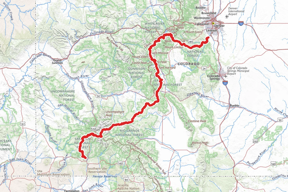
485-mile thru-hike planner: permits, resupply and the places along the route

- Markers
- 105
- Resources
- 1
- Distance
- 485.0 mi
- Elevation
- —
- Markers
- 105
- Resources
- 1
- Distance
- 485.0 mi
- Elevation
- —
Notes
Permits and official resources
Straight from the agencies and the trail's managing association. Rules and permit systems change, so check these pages before you go.
Permits
- Lost Creek Wilderness — free self-issued wilderness permit USDA Forest Service — Pike-San Isabel National Forests
- Holy Cross Wilderness — free self-issue overnight registration (White River NF) USDA Forest Service — White River National Forest
- Holy Cross Wilderness — overnight permit (Pike-San Isabel NF side) USDA Forest Service — Pike-San Isabel National Forests
- Waterton Canyon rules (no dogs, camping limits) Denver Water
- Clear Creek Reservoir State Wildlife Area — hunting/fishing license or SWA pass (Segment 12, Collegiate East) Colorado Parks and Wildlife
Plan your hike
- Colorado Trail — San Juan National Forest USDA Forest Service — San Juan National Forest
- Colorado Trail #1776 (North Cottonwood) USDA Forest Service — Pike-San Isabel National Forests
- Colorado Trail — Junction Creek Trail (southern terminus) USDA Forest Service — San Juan National Forest
- La Garita Wilderness (CT/CDT on the divide) USDA Forest Service — Rio Grande National Forest
- Brave the Elements — lightning and altitude USDA Forest Service — Pike-San Isabel National Forests
- Rocky Mountain Region FAQs (wilderness permits and registration) USDA Forest Service — Rocky Mountain Region
- Hiking and Backpacking the CT Colorado Trail Foundation
- Alerts, Closures & Reroutes (map, blog posts, and text-alert sign-up) Colorado Trail Foundation
- Water Sources & Treatment (dry stretches, the Segment 2 spigot) Colorado Trail Foundation
- Resupply Towns (distance from the trail and services, south from Denver) Colorado Trail Foundation
- Food Storage (canister recommendation) Colorado Trail Foundation
- Starting Points (getting to Waterton Canyon and Junction Creek; parking) Colorado Trail Foundation
- Shuttlers & Angels (request the volunteer shuttle list) Colorado Trail Foundation
- Snowpack (melt-out estimates by segment and SNOTEL rules of thumb) Colorado Trail Foundation
- Traveling Safely (sheriff offices by segment; satellite messengers; CORSAR card) Colorado Trail Foundation
Who to call
- South Platte Ranger District, Pike-San Isabel NF (Lost Creek Wilderness; Waterton Canyon/Segments 1-3)USDA Forest Service — Pike-San Isabel National Forests303-275-561030403 Kings Valley Drive, Suite 2-115 Conifer, CO 80433
- Leadville Ranger District, Pike-San Isabel NF (Holy Cross Wilderness, PSICC side)USDA Forest Service — Pike-San Isabel National Forests719-486-0749810 Front Street Leadville, CO 80461
- Eagle-Holy Cross Ranger District, White River NF (Holy Cross Wilderness, White River side)USDA Forest Service — White River National Forest970-827-571524747 US Highway 24 Minturn, CO 81645
- Denver Water — Waterton Canyon (owner, operator and recreation manager)Denver Water303-893-2444recreation@denverwater.org
- Salida Ranger District, Pike-San Isabel NF (Collegiate segments)USDA Forest Service — Pike-San Isabel National Forests719-539-35915575 Cleora Road Salida, CO 81201
- Saguache Ranger District, Rio Grande NF (La Garita Wilderness)USDA Forest Service — Rio Grande National Forest(719) 655-254746525 State Highway 114 Saguache, CO 81149
- Columbine Ranger District, San Juan NF (Junction Creek / southern terminus)USDA Forest Service — San Juan National Forest(970) 884-2512367 Pearl Street Bayfield, CO 81122
- San Juan National Forest Supervisor's OfficeUSDA Forest Service — San Juan National Forest(970) 247-487415 Burnett Court Durango, CO 81301
Books for the trail
- Colorado Trail Guidebook (opens in new tab)Guidebook · The Colorado Trail Foundation · The Colorado Trail Foundation · 10th EditionThe Foundation's own planning guide: a chapter per segment with access roads, water, camping, resupply and wilderness bike detours.
- Colorado Trail Databook (opens in new tab)Data book · The Colorado Trail Foundation · The Colorado Trail Foundation · 8th EditionPocket mile-by-mile book: water sources with reliability symbols, resupply towns, maps and elevation profiles for every segment.
- Colorado Trail Map Book (opens in new tab)Maps · Bear Creek Survey / The Colorado Trail Foundation · The Colorado Trail Foundation · Current editionShaded-relief topo maps of all 567 miles with about 1,200 milepoint waypoints; the Foundation's store lists it, check stock.
- National Geographic Map Guide - Colorado Trail North (opens in new tab)Maps · National Geographic Maps with The Colorado Trail Foundation · National Geographic MapsWaterproof topo booklet for Denver to Highway 50 (Collegiate East), with elevation profiles and a resupply chart; South and Collegiate Loop volumes cover the rest.
- National Geographic Map Guide – Colorado Trail South (opens in new tab)Maps · National Geographic Maps with The Colorado Trail Foundation · National Geographic MapsThe southern volume of the waterproof map-guide set, Highway 50 to Durango.
- Over Hill and Over Dale (opens in new tab)History · Doug FreedHistory of the places the trail passes, by a CT completer; sold by the Foundation.
- I Digress (opens in new tab)Guidebook · Peter GrosshueschA segment-by-segment guide with turn-by-turn directions to trailheads, for hiking the trail in sections, by a 2023 CT completer; independent, not an official Foundation publication.
- The Colorado Way (opens in new tab)Narrative · Matt PaynePhotographs and personal essays from a photographer who walked the Colorado Trail; sold by the Foundation.
Links go to the publisher or the trail association. Check for the current edition.
Checkpoints
- 1
Waterton Canyon, southwest of Denver, CO
Mile zero for most thru-hikers. The first 6.7 miles follow an unpaved Denver Water road up the South Platte. It is closed to public vehicles but open to foot, bike and horse traffic, and it is a working facility, so expect the odd vehicle or piece of equipment. No dogs or other pets in the canyon: the rule protects the bighorn sheep. If your dog is coming, the Foundation suggests it join you at the South Platte River Trailhead, or that you start at the Indian Creek Trailhead instead. There is no camping and no fires on the first 6.7 miles, no e-bikes, and no swimming or wading. Overnight parking is not allowed in the trailhead lot, so arrange a ride to 11300 Waterton Road. The closest light-rail stop is Mineral Station in Littleton, about 10 miles away. Before you leave home, get the Foundation's Official Guidebook and Databook. It calls them your in-pocket resource for water sources, mileage and elevation, and says to buy or borrow the latest edition, because reroutes are built nearly every season and older guides no longer describe the current route. For the ride to the trailhead, the Foundation keeps a list of volunteer shuttle drivers in Denver and the trail towns. It sends the list only on request, and drivers usually need to be booked in advance.
- 2
Junction Creek Trailhead, near Durango, CO
The Durango end of the Colorado Trail, about three and a half miles up Junction Creek Road from Main Avenue. Parking is small and in demand, and the Foundation advises against leaving a car here for long: get a ride, or walk out from a room in town. The Forest Service lists restrooms here as open seasonally. Heading north, the first couple of miles follow Junction Creek. After a wooden footbridge at about mile 2.5 the trail starts to climb, and at mile 3.8 it reaches Gudy's Rest, a lookout back toward Durango. From the trailhead to Kennebec Pass it gains 4,790 feet, the biggest single climb on the CT. Water is scarce once you leave the canyon floor, so fill up before the climb. Flash floods can run through the flood plains, and there is poison ivy.
Landmarks (2)
Markers (105)
Trails (1)
Reviews
No reviews yet
Be the first to share your experience and help others plan their visit.