Thru-hike planner
Arizona National Scenic Trail
Thru-hike planner
Arizona National Scenic Trail
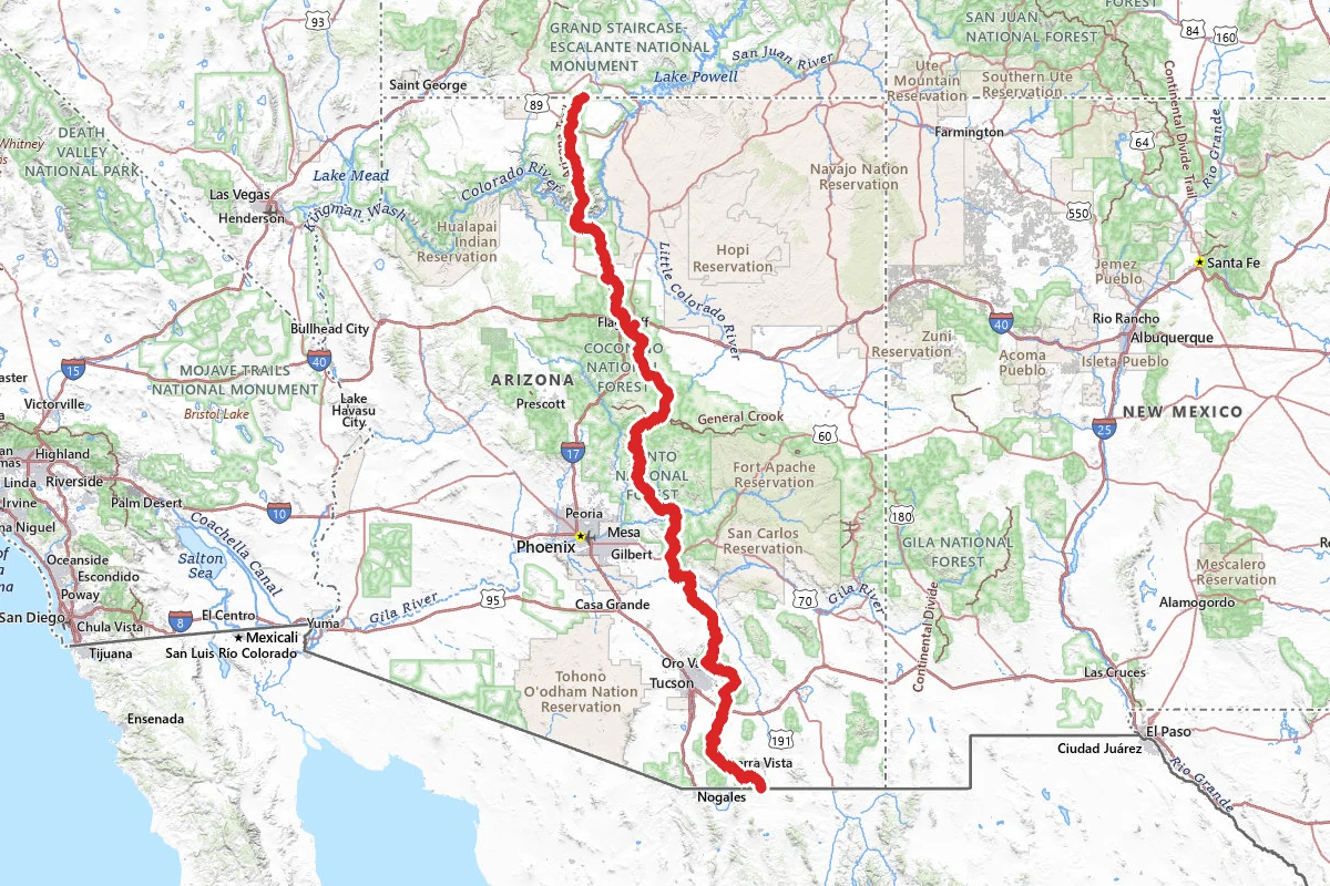
800-mile thru-hike planner: permits, resupply and the places along the route

- Markers
- 214
- Resources
- 1
- Distance
- 800.0 mi
- Elevation
- —
- Markers
- 214
- Resources
- 1
- Distance
- 800.0 mi
- Elevation
- —
Notes
Permits and official resources
Straight from the agencies and the trail's managing association. Rules and permit systems change, so check these pages before you go.
Permits
- Saguaro National Park backcountry camping (AZT thru-hiker overnight permit) National Park Service — Saguaro National Park
- Saguaro National Park permits on Recreation.gov National Park Service (Recreation.gov)
- Grand Canyon National Park backcountry permit National Park Service — Grand Canyon National Park
- Cienega Creek Natural Preserve — no permit needed if you stay on the Arizona Trail Pima County
Plan your hike
- Arizona National Scenic Trail FAQs USDA Forest Service
- Hazards & Considerations Arizona Trail Association
- Water Sources Arizona Trail Association
- Current closures, restrictions and reroutes Arizona Trail Association
- Grand Canyon key hiking messages and closures National Park Service — Grand Canyon National Park
- Coronado National Memorial hiking (southern terminus) National Park Service — Coronado National Memorial
- The Trail Arizona Trail Association
- Dogs on the Trail (where dogs are not allowed) Arizona Trail Association
- Shuttles (southern terminus, Grand Canyon, Stateline) Arizona Trail Association
- Gateway Communities (resupply towns, package holders, post offices) Arizona Trail Association
- Databooks (members-only PDF by passage) Arizona Trail Association
- Maps of the Trail (topo set, interactive map, Google Earth file) Arizona Trail Association
- Permits Arizona Trail Association
- Trail Angels Arizona Trail Association
Who to call
- Arizona Trail Association602-252-4794ata@aztrail.org738 N. 5th Avenue, #201 Tucson, AZ 85705
- Arizona National Scenic Trail (USDA Forest Service AZNST Administrator)USDA Forest Service2324 E. McDowell Road Phoenix, AZ 85006
- Grand Canyon NP Backcountry Information CenterNational Park Service — Grand Canyon National Park928-638-78751824 S. Thompson St., Suite 201 Flagstaff AZ, 86001
- Saguaro National Park — Rincon Mountain District (East)National Park Service — Saguaro National Park(520) 733-51533693 South Old Spanish Trail Tucson, AZ 85730-5601
- Saguaro National Park HeadquartersNational Park Service — Saguaro National Park(520) 733-5100
- Grand Canyon National Park (general park information)National Park Service — Grand Canyon National Park928-638-7888PO Box 129 Grand Canyon, AZ 86023
- Coronado National Memorial (southern terminus)National Park Service — Coronado National Memorial520 366-55154101 E Montezuma Canyon Road Hereford, AZ 85615
Books for the trail
- Your Complete Guide to the Arizona National Scenic Trail (opens in new tab)Guidebook · Arizona Trail AssociationThe guidebook the association sells: descriptions of all 43 passages with topo maps, elevation profiles and trailhead directions, plus water sources and gateway-community profiles.
- Arizona Trail Databook (opens in new tab)Data book · Arizona Trail Association · Arizona Trail AssociationPassage-by-passage miles, elevations, waypoints, water sources and campsites; a members-only download from the association.
- Arizona Trail Topo Map Set (opens in new tab)Maps · Arizona Trail Association · Arizona Trail AssociationThe association's printed topo map set, with an elevation chart on each map, accumulated trail mileage every mile and almost 800 data points including water sources; also sold for the Avenza app.
- Arizona Trail Day Hiker’s Guide (opens in new tab)Guidebook · Jake Baechle (Arizona Trail Association) · Arizona Trail Association · Updated May 2025Splits the trail into 89 day hikes with access directions and road conditions; useful for section hikers and for bail-out access points.
- Pedaling Home (opens in new tab)Narrative · Sarah Ruth JansenA woman races a bicycle 750 miles along the Arizona Trail from Mexico to Utah, carrying it through the Grand Canyon; sold by the association.
- Memorizing Shadows (opens in new tab)Narrative · Heidi Elizabeth BlankenshipPoems and paper-cut art made on a walk of the whole trail; sold by the association.
Links go to the publisher or the trail association. Check for the current edition.
Checkpoints
- 1
Coronado National Memorial, US-Mexico border
Border Monument 102 marks the US-Mexico border and the southern terminus of the Arizona Trail. You reach it on the Yaqui Ridge Trail, a steep spur off Joe's Canyon Trail, and the walk from Montezuma Pass to the border and back is 4 miles. The Arizona Trail Association reports the southernmost mile, from the monument to the Joe's Canyon junction, closed until further notice for border wall construction, and concertina wire at the fence keeps you away from the monument itself. Check its Passage 1 page before you plan a start or a finish here, and don't cross the wire or the fence. Dogs and horses are not allowed on this first 1.8 miles inside the Memorial. Cell service is unreliable, the park recommends against hiking alone or travelling cross-country, and it asks you to report anything suspicious to park staff or the Border Patrol rather than make contact.
Landmarks (114)
Markers (214)
Trails (1)
Reviews
No reviews yet
Be the first to share your experience and help others plan their visit.