Mount Sneffels: The San Juans' jagged showpiece, and the V-notch that promotes you to Class 3
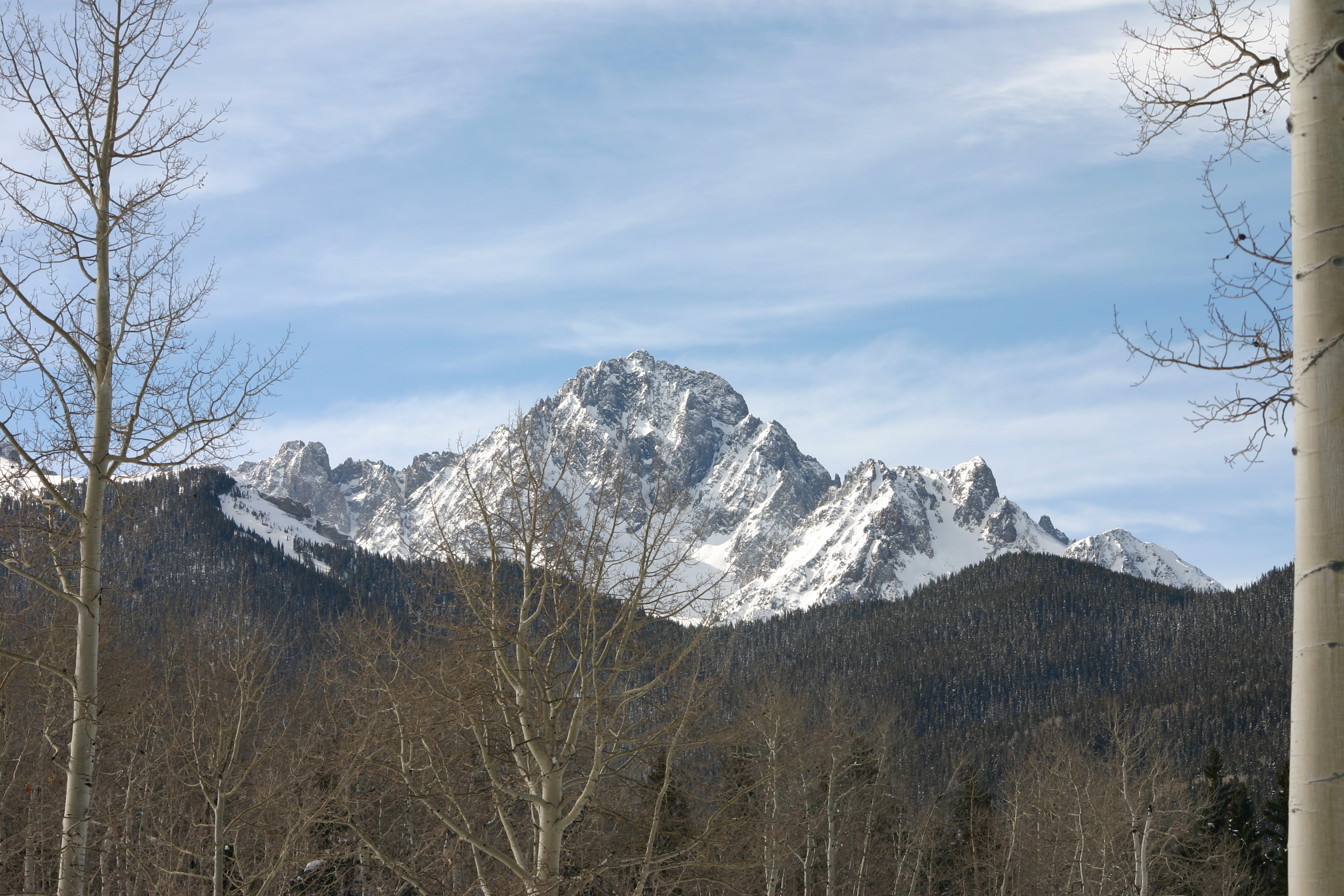
Y'all, Mount Sneffels is the most-photographed peak in the Sneffels Range — that aspen-and-alpine-flower mountain looming over Yankee Boy Basin above Ouray. The standard route ends in a 50-foot Class 3 chimney called the V-notch. Heck of a finish.

If you've ever seen a calendar photo of fall colors framing a jagged Colorado peak, there's a good chance you've seen Mount Sneffels. The mountain looms over Yankee Boy Basin above Ouray — its sharp east face rising over an aspen-fringed alpine meadow that turns gold and rust in late September. Heck of a thing to look at. Sneffels is one of the most-photographed alpine subjects in the state and the recognized king of the Sneffels Range, the rugged subgroup of the San Juans north of Telluride.
The standard climbing route is short by 14er standards — 6 miles round-trip — but it ends in a 50-foot Class 3 chimney called the V-notch. This is where a lot of Coloradans first try sustained Class 3 scrambling with real exposure. It's a heck of a way to graduate.
The peak at a glance
- Elevation: 14,158 ft (4,315 m)
- Rank in Colorado: 29th of 56 peaks above 14,000 ft
- Range: Sneffels Range / San Juan Mountains
- County: Ouray County
- Coordinates: 38.0033° N, 107.7920° W
- Standard route: South Slopes via Yankee Boy Basin (Class 3) — 6 mi round-trip, ~2,900 ft gain
- Public land: Mount Sneffels Wilderness, Uncompahgre National Forest
How Mount Sneffels got its name
The naming is contested. The most-cited theory traces "Sneffels" to Snæfellsjökull, the Icelandic glacier-volcano that opens Jules Verne's Journey to the Center of the Earth (1864). Local stories hold that members of the 1874 Hayden Survey, fresh into the basin and reading Verne, slapped the name on the peak in homage. A competing theory treats it as a phonetic Anglicization of an older Norse mining-engineer's surname. The Hayden-meets-Verne version is the romance; the Anglicization version is more documentable.
Either way, the peak shows up as "Mount Sneffels" on the Hayden Survey's 1874 map. Heck of a name origin for a Colorado mountain.
The standard route
The standard South Slopes route starts from the upper Yankee Boy Basin trailhead at 11,400 feet (4WD road only — passenger cars stage lower at the Wright's Lake junction and walk it). The trail climbs talus into a steep couloir up to Lavender Col at 13,500 feet. From the col, the route turns up a final 600-foot chimney — the V-notch — and finishes with a 50-foot Class 3 scramble out the top onto the summit ridge.
The V-notch is the crux. Exposure is real but the holds are good. Most fit hikers handle it. Helmet and gloves — y'all wear them — because that chimney is a natural rockfall channel and other parties above you will dislodge stuff.
Round trip is 6 miles with about 2,900 feet of gain. Plan on 6 to 8 hours car-to-car. Heck of a bang for the buck.
Other ways up
Two harder lines for climbers stepping up:
- Southwest Ridge: A more sustained Class 3 ridge climb with multiple committing steps. Adds technical interest but bypasses the famous V-notch.
- Snake Couloir (north face): A 1,200-foot snow climb up the dramatic north face. Late-spring conditions; serious mountaineering objective requiring crampons, ice axe, and avalanche assessment.
When to climb
The Colorado fourteener climbing season is short. The standard window runs from late June through mid-September — after the snow has melted off the trail and before the first serious autumn storm. Outside that window, you're committing to a winter ascent: snow travel, avalanche assessment, post-holing through drifts, and route-finding without a visible trail.
Inside the window, the rule that has saved more Colorado lives than any other is be off the summit by noon. Afternoon convective storms build over the high peaks almost daily in July and August. Lightning is the leading weather killer in the Rockies. Plan for a pre-dawn start — most experienced climbers leave the trailhead between 4:00 and 5:30 AM.
Where it sits
The peak sits inside the Mount Sneffels Wilderness, accessed from Ouray on the north side and Telluride on the south. Yankee Boy Basin is up a steep, rocky 4WD road — ten miles out of Ouray on Camp Bird Road, with sections that demand real clearance above the summer-only upper trailhead. Folks in passenger cars stage from the Wright's Lake junction and walk up the rest.
The same road accesses Twin Falls and Yankee Boy itself — one of the great wildflower basins in the San Juans, with peak bloom usually in late July. Heck of a place to spend a morning.
What climbers wish they'd known
The V-notch is wet. Snow lingers in that upper chimney into July most years. Step around the snow if you can; if it's wall-to-wall, the chimney becomes a serious mountaineering objective and most folks should turn around or come back later.
Time the climb for late September. The aspens around Yankee Boy Basin in the last week of September are heck of a thing — among the most beautiful alpine drives and climbs in Colorado, period. If you can pick your weekend, this is the one.
Before you go
A 14er is a long, exposed day at altitude. Read these first if you haven't already:
- Planning your first multi-day backpacking trip — same logistics apply to a long single-day summit push.
- How to choose the right trail difficulty — converting class ratings into honest fitness estimates.
- Leave No Trace, in one minute — alpine tundra heals on a geological clock. Stay on the trail.
Looking for the standard route on the map? Browse Colorado trails on the Outdoors App or jump to the Near Me view if you're already in-state.
If you liked this peak
- Wilson Peak — the Coors Beer mountain
- Mount Wilson — the higher Wilson
- Wetterhorn Peak — the Swiss-named San Juan summit
Hero photograph: Mount Sneffels rising above its namesake basin, San Juan Mountains, Colorado. by Alex Kerney, licensed under CC BY 2.0.


