1 / 2
National Forest
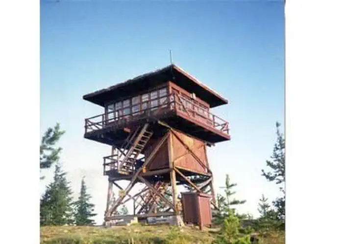
Surveyors Lookout
St. Joe National Forest · Avery, ID
Verify with the local Forest Service ranger district
Forest Service campgrounds vary by district. Fire restrictions, road conditions, and operating dates are set locally and change seasonally. Call the ranger district to confirm.
Pricing
Check official pricing0.0
0 Reviews
Official sources & verification
Managed by US Forest Service
Reserve or permit
- Reserve on Recreation.gov
Book a site directly with the operator.
Managing agency
- US Forest Service
Find offices, alerts, and current orders for this agency.
Verify by phone or mail
- Address:Avery, ID
About
Overview
Located near the Mallard-Larkins Pioneer Area Attractions, Surveyors Lookout is perched atop a 30 foot tower, providing phenomenal views of Snow Peak and the surrounding mountains. The cabin is listed on the National Historic Register for Lookouts and offers visitors a unique camping experience in the Idaho Panhandle National Forest.
The original pole structure lookout was built in 1931 as part of a network of lookouts used to spot fires in the Upper St. Joe Country. The original lookout was replaced with the current treated timber structure in 1964.
Access to the lookout is via a rugged single-lane road with pullouts, and is not recommended for low clearance vehicles. Road may be slick when wet.
Recreation
The Mallard-Larkins Pioneer Area straddles the divide between the Little North Fork Clearwater River basins and the North Fork Clearwater River. This beautiful area attracts hikers and some technical rock climbers. Hunting and trout fishing are offered in designated areas.
From the lookout, there is access to Scribner Falls Trail 106 and nearby access to Surveyor's Ridge Trail 40, Horseshoe Loop Trail 141, and Northbound Creek Trail 111.
A scenic drive through the upper St. Joe country is an excellent way to take in the sights leading up to the lookout.
Facilities
Surveyors Lookout can accommodate up to four guests. Furnishings include a propane cook stove, heater and lights. A twin bed and two extra mattresses are provided, along with a chest with some drawers. A refrigerator is also available, but it is very small and unreliable. It is recommended that guests bring a cooler with ice as backup. Cooking pots and utensils are included.
No drinking water is available; guests should bring plenty of their own. An alternate option is to collect water from a spring located 1.4 miles down the access road. This water is non-potable and must be boiled or treated before consuming.
Items to pack include food, bedding, a first aid kit, dish soap, towels, toiletries and binoculars. If planning to collect water from a stream, water containers are needed. Guests are advised to bring warm clothes and blankets for cold evenings. Although a heater is provided, the lookout is not insulated so it remains cold.
Natural Features
Surveyors Lookout is located atop Surveyors Ridge at an elevation of 6,000 feet. The 30 foot tower overlooks the spectacular Mallard-Larkins Pioneer Area, which straddles the divide between the Little North Fork Clearwater River basins and the North Fork Clearwater River. Snow Peak, Middle Sister and Mallard Peak Lookouts are still standing and can be seen from Surveyors.
Nearby Attractions
Avery is the nearest town for conveniences.
Reviews
No reviews yet
Be the first to share your experience and help others plan their visit.
Pet Policy
No pets allowed
Campground Rules
- No campfires allowed
In this park
Trails at St. Joe National Forest
White Pine National Recreation Trail
3 mi883 ftmoderate
Mary Minerva McCroskey Memorial State Park Loop Trail
4 mi909 ftmoderate
Sand Mountain Lookout Trail
4.6 mi1,444 ftmoderate
Saint Joe River from Spruce Tree Campground
5.3 mi1,437 ftmoderate
Saint Joe Lake Trail
9.8 mi2,172 ftdifficult
Snow Peak
8.2 mi2,697 ftdifficult
Within ~30 miles
Trails near Surveyors Lookout
Trail
Snow Peak
Idaho
8.2 mi2,697 ftgain
Difficult
Trail
Larkins Lake Trail
Idaho
12.4 mi3,970 ftgain
Expert
Trail
Saint Joe River from Spruce Tree Campground
Idaho
5.3 mi1,437 ftgain
Moderate
Trail
Bacon Peak Loop
Montana
22.7 mi6,788 ftgain
Expert
Trail
St. Joe NF Trail 17
Idaho
4.3 mi2,083 ftgain
Difficult
Trail
St. Joe Forest Service Road Trail 1281
Idaho
7.0 mi3,012 ftgain
Difficult
Hunt context
Hunting units around this campground
During hunting seasons, wear blaze orange and check regulations — see the Montana hunting page
Nearby Campgrounds

Spot an error in our data on Surveyors Lookout?