State Park
Koocanusa Area
Rexford, MT
Pricing varies — check with the operator
Verify with the state park system
State parks set their own rules and reservation systems. Fire bans, road closures, and operating dates change seasonally — check the state park website before traveling.
Pricing
Pricing varies — check with the operator0.0
0 Reviews
Official sources & verification
Managed by State Park
Verify by phone or mail
- Address:Rexford, MT
About
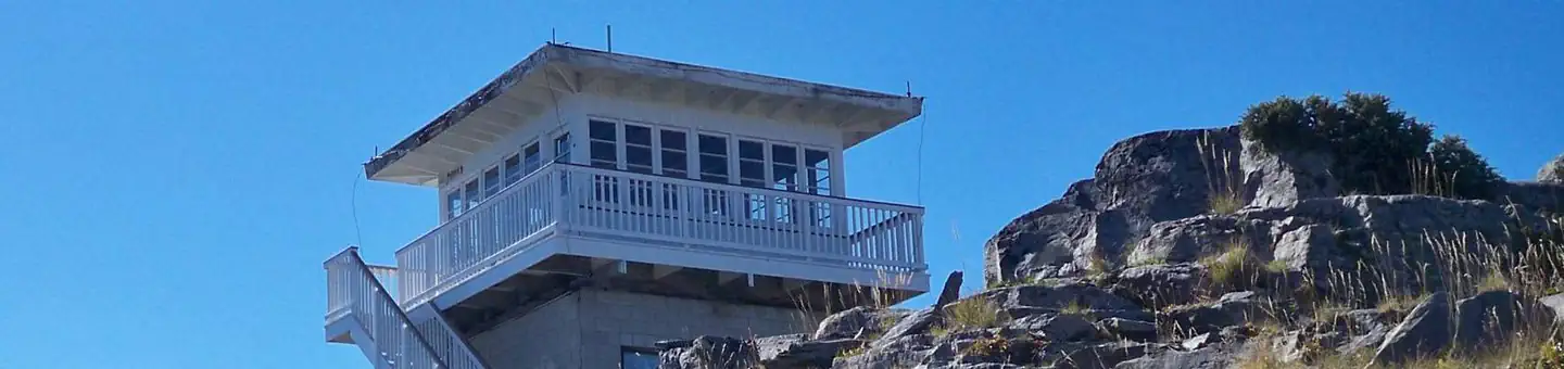
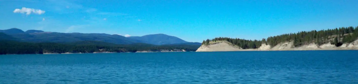
The Koocanusa Area is primarily centered along a narrow 90 mile long Koocanusa Reservoir, formed by Libby Dam. Approximately 60 miles are within the United States. Libby Dam is operated by the US Army Corps of Engineers which provides daily dam tours. Koocanusa Reservoir is the major recreation attraction in this geographic area, providing ideal settings for large watercraft and sailing. The reservoir contains a large and stable population of Kookanee salmon, Kamloops (rainbow) trout, bull trout, West slope cutthroat trout and burbot. Fishing has been reported to be fantastic. There are a number of large developed recreation complexes along the reservoir shoreline including: Rexford Bench, McGillivray, Peck Gulch, and Rocky Gorge. Campgrounds, picnic areas, swimming beaches, boat ramps, as well as day use areas comprise many of the facilities within these developed sites. In addition there are two marina complexes located on the reservoir, one on the southern end, at Cripple Horse, while the northern portion of the reservoir has Mariners Haven Resort near the Town of Rexford. There are also a number of private RV parks, restaurants, and stores near the marinas or within the surrounding communities of West Kootenai, Rexford, Eureka and Libby. Two paved highways running adjacent to the reservoir and extending from Eureka to Libby have been designated by the State of Montana as a Scenic Byway. Traffic is light and views along the roadways are memorable, including glimpses of the Ural-Tweed Big Horn Sheep herd, located on the eastern side of the reservoir along Hwy 37, Various mountain ranges create the geographic setting; Purcell Mountains located west of Koocanusa Reservoir while the Salish Mountains are located on the eastern side. The Koocanusa Area is the perfect setting for year round recreational attractions, including: fishing, water sports, rock and ice climbing, and driving for pleasure, especially during the fall Western Larch color change. Stone Hill climbing area is also located adjacent to Hwy 37 just south of Koocanusa Bridge. The climbing area offers in excess of 70 established climbing routes. Many climbers use the site as an opportunity to hone their climbing skills or to introduce new climbers to the sport. Koocanusa Bridge located at Mile Post 53, approximately 6 miles south of the Town of Rexford. It is the longest and highest bridge in Montana. The bridge connects Hwy 37 to the Western side of the reservoir and recreational opportunities such as road access to the Yaak River valley, the community of West Kootenai, and numerous hiking trails and fishing creeks. Located on the western side is a former fire lookout cabin that is now available for the public to rent. The Koocanusa Area is the perfect setting for a large-water based recreation vacation. Fish Your National Forests: This site can be accessed by Passenger Car; Fish available include: Trout, Native Trout; Types of fishing available include: Wade, Shore, Motorized boat, Float tube, Spin, Bait; ADA Accessible fishing access with boat launch
Reviews
No reviews yet
Be the first to share your experience and help others plan their visit.
Pet Policy
No pets allowed
Campground Rules
- No campfires allowed
Within ~30 miles
Trails near Koocanusa Area
Trail
Little North Fork Falls
Montana
0.4 mi190 ftgain
Easy
Trail
Bluebird Lake Via Highline Trail
Montana
4.6 mi1,237 ftgain
Moderate
Trail
Little Therriault Lake Trail
Montana
1.0 mi128 ftgain
Easy
Trail
Ant Flat Historical Site Nature Trail
Montana
0.3 mi49 ftgain
Easy
Trail
Big Therriault Lake to Therriault Pass Loop
Montana
5.4 mi1,965 ftgain
Difficult
Trail
Murphy Lake
Montana
0.7 mi144 ftgain
Easy
Hunt context
Hunting units around this campground
During hunting seasons, wear blaze orange and check regulations — see the Montana hunting page
Nearby Campgrounds

Spot an error in our data on Koocanusa Area?